You are here: Home > Network List > UW - Pacific Northwest Regional Seismic Network Stations List
> Station LEBA Lebam, WA, USA > Earthquake Result Viewer
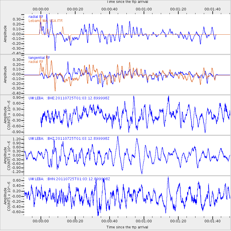
LEBA Lebam, WA, USA - Earthquake Result Viewer
*The percent match for this event was below the threshold and hence no stack was calculated.
| Earthquake location: |
New Ireland Region, P.N.G. |
| Earthquake latitude/longitude: |
-3.2/150.6 |
| Earthquake time(UTC): |
2011/07/25 (206) 00:50:47 GMT |
| Earthquake Depth: |
10 km |
| Earthquake Magnitude: |
5.9 MB, 6.3 MS, 6.4 MW, 6.3 MW |
| Earthquake Catalog/Contributor: |
WHDF/NEIC |
|
| Network: |
UW Pacific Northwest Regional Seismic Network |
| Station: |
LEBA Lebam, WA, USA |
| Lat/Lon: |
46.55 N/123.56 W |
| Elevation: |
73 m |
|
| Distance: |
89.4 deg |
| Az: |
43.504 deg |
| Baz: |
264.799 deg |
| Ray Param: |
$rayparam |
*The percent match for this event was below the threshold and hence was not used in the summary stack. |
|
| Radial Match: |
66.45796 % |
| Radial Bump: |
400 |
| Transverse Match: |
62.85439 % |
| Transverse Bump: |
400 |
| SOD ConfigId: |
405110 |
| Insert Time: |
2011-12-29 06:39:15.751 +0000 |
| GWidth: |
2.5 |
| Max Bumps: |
400 |
| Tol: |
0.001 |
|
Signal To Noise
| Channel | StoN | STA | LTA |
| UW:LEBA: :BHZ:20110725T01:03:12.899998Z | 1.854607 | 3.183296E-7 | 1.7164261E-7 |
| UW:LEBA: :BHN:20110725T01:03:12.899998Z | 0.85140395 | 1.8552561E-7 | 2.1790551E-7 |
| UW:LEBA: :BHE:20110725T01:03:12.899998Z | 1.626685 | 3.7300842E-7 | 2.2930587E-7 |
| Arrivals |
| Ps | |
| PpPs | |
| PsPs/PpSs | |


