You are here: Home > Network List > AU - Australian Seismological Centre Stations List
> Station FORT Forrest, Western Australia > Earthquake Result Viewer
FORT Forrest, Western Australia - Earthquake Result Viewer
| Earthquake location: |
Luzon, Philippines |
| Earthquake latitude/longitude: |
14.9/120.0 |
| Earthquake time(UTC): |
2011/07/25 (206) 17:15:40 GMT |
| Earthquake Depth: |
35 km |
| Earthquake Magnitude: |
5.9 MB, 5.4 MS, 5.9 MW, 5.8 MW |
| Earthquake Catalog/Contributor: |
WHDF/NEIC |
|
| Network: |
AU Australian Seismological Centre |
| Station: |
FORT Forrest, Western Australia |
| Lat/Lon: |
30.78 S/128.06 E |
| Elevation: |
165 m |
|
| Distance: |
46.1 deg |
| Az: |
170.414 deg |
| Baz: |
349.22 deg |
| Ray Param: |
0.07077777 |
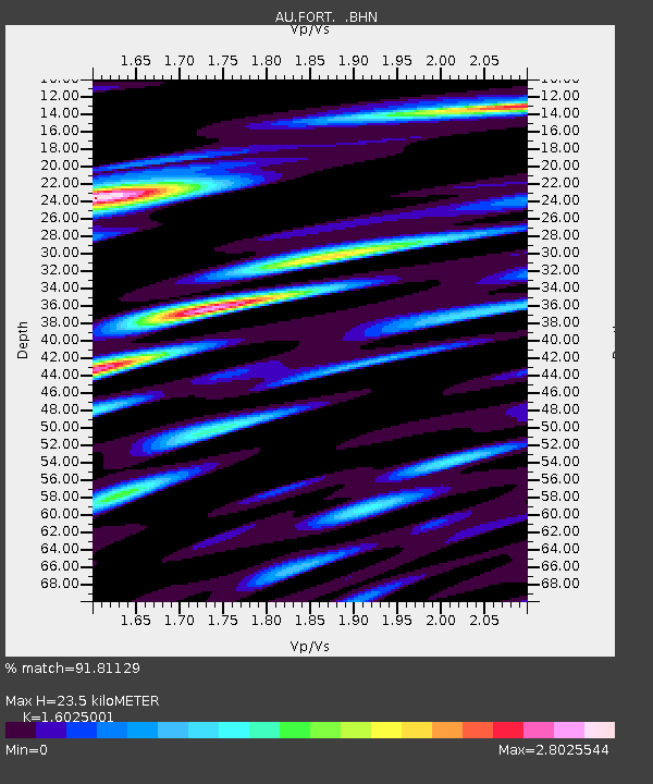
| Estimated Moho Depth: |
23.5 km |
| Estimated Crust Vp/Vs: |
1.60 |
| Assumed Crust Vp: |
6.479 km/s |
| Estimated Crust Vs: |
4.043 km/s |
| Estimated Crust Poisson's Ratio: |
0.18 |
|
| Radial Match: |
91.81129 % |
| Radial Bump: |
375 |
| Transverse Match: |
81.792435 % |
| Transverse Bump: |
400 |
| SOD ConfigId: |
405110 |
| Insert Time: |
2011-12-29 06:47:11.386 +0000 |
| GWidth: |
2.5 |
| Max Bumps: |
400 |
| Tol: |
0.001 |
|

Signal To Noise
| Channel | StoN | STA | LTA |
| AU:FORT: :BHZ:20110725T17:23:31.095004Z | 5.041282 | 8.669144E-6 | 1.7196307E-6 |
| AU:FORT: :BHN:20110725T17:23:31.095004Z | 2.6965296 | 6.199198E-6 | 2.298954E-6 |
| AU:FORT: :BHE:20110725T17:23:31.095004Z | 2.093094 | 4.807419E-6 | 2.2968E-6 |
| Arrivals |
| Ps | 2.3 SECOND |
| PpPs | 8.8 SECOND |
| PsPs/PpSs | 11 SECOND |


