You are here: Home > Network List > G - GEOSCOPE Stations List
> Station CAN Canberra, Australia > Earthquake Result Viewer
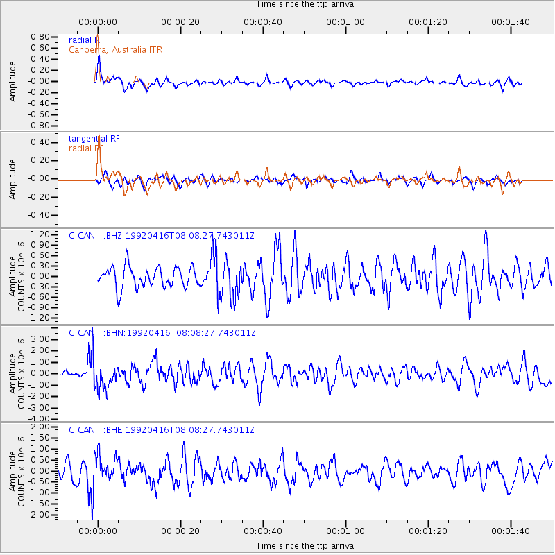
CAN Canberra, Australia - Earthquake Result Viewer
*The percent match for this event was below the threshold and hence no stack was calculated.
| Earthquake location: |
Minahassa Peninsula, Sulawesi |
| Earthquake latitude/longitude: |
1.2/122.5 |
| Earthquake time(UTC): |
1992/04/16 (107) 08:00:55 GMT |
| Earthquake Depth: |
41 km |
| Earthquake Magnitude: |
5.7 MB, 5.6 MS |
| Earthquake Catalog/Contributor: |
WHDF/NEIC |
|
| Network: |
G GEOSCOPE |
| Station: |
CAN Canberra, Australia |
| Lat/Lon: |
35.32 S/149.00 E |
| Elevation: |
650 m |
|
| Distance: |
43.9 deg |
| Az: |
148.318 deg |
| Baz: |
320.05 deg |
| Ray Param: |
$rayparam |
*The percent match for this event was below the threshold and hence was not used in the summary stack. |
|
| Radial Match: |
72.41646 % |
| Radial Bump: |
378 |
| Transverse Match: |
45.06337 % |
| Transverse Bump: |
394 |
| SOD ConfigId: |
4480 |
| Insert Time: |
2010-02-26 21:49:50.027 +0000 |
| GWidth: |
2.5 |
| Max Bumps: |
400 |
| Tol: |
0.001 |
|
Signal To Noise
| Channel | StoN | STA | LTA |
| G:CAN: :BHN:19920416T08:08:27.743011Z | 2.613324 | 1.0433831E-6 | 3.992552E-7 |
| G:CAN: :BHE:19920416T08:08:27.743011Z | 1.6979892 | 5.819779E-7 | 3.4274535E-7 |
| G:CAN: :BHZ:19920416T08:08:27.743011Z | 1.8614837 | 5.463306E-7 | 2.93492E-7 |
| Arrivals |
| Ps | |
| PpPs | |
| PsPs/PpSs | |


