You are here: Home > Network List > IW - Intermountain West Stations List
> Station MOOW Moose Ponds, Wyoming, USA > Earthquake Result Viewer
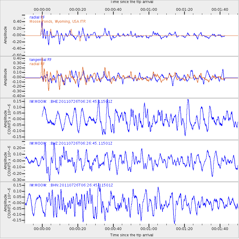
MOOW Moose Ponds, Wyoming, USA - Earthquake Result Viewer
*The percent match for this event was below the threshold and hence no stack was calculated.
| Earthquake location: |
Off East Coast Of Kamchatka |
| Earthquake latitude/longitude: |
53.0/159.8 |
| Earthquake time(UTC): |
2011/07/26 (207) 06:17:37 GMT |
| Earthquake Depth: |
33 km |
| Earthquake Magnitude: |
5.6 MW, 5.1 MS, 5.4 MB, 5.4 MW |
| Earthquake Catalog/Contributor: |
WHDF/NEIC |
|
| Network: |
IW Intermountain West |
| Station: |
MOOW Moose Ponds, Wyoming, USA |
| Lat/Lon: |
43.75 N/110.74 W |
| Elevation: |
2128 m |
|
| Distance: |
56.4 deg |
| Az: |
60.432 deg |
| Baz: |
313.485 deg |
| Ray Param: |
$rayparam |
*The percent match for this event was below the threshold and hence was not used in the summary stack. |
|
| Radial Match: |
65.65338 % |
| Radial Bump: |
400 |
| Transverse Match: |
57.753273 % |
| Transverse Bump: |
400 |
| SOD ConfigId: |
405110 |
| Insert Time: |
2011-12-29 07:00:31.981 +0000 |
| GWidth: |
2.5 |
| Max Bumps: |
400 |
| Tol: |
0.001 |
|
Signal To Noise
| Channel | StoN | STA | LTA |
| IW:MOOW: :BHZ:20110726T06:26:45.11501Z | 3.9134707 | 1.5287284E-7 | 3.9063238E-8 |
| IW:MOOW: :BHN:20110726T06:26:45.11501Z | 1.2114327 | 5.8614887E-8 | 4.8384766E-8 |
| IW:MOOW: :BHE:20110726T06:26:45.11501Z | 1.4351448 | 7.6571794E-8 | 5.3354754E-8 |
| Arrivals |
| Ps | |
| PpPs | |
| PsPs/PpSs | |


