You are here: Home > Network List > TA - USArray Transportable Network (new EarthScope stations) Stations List
> Station 336A Riesel, TX, USA > Earthquake Result Viewer
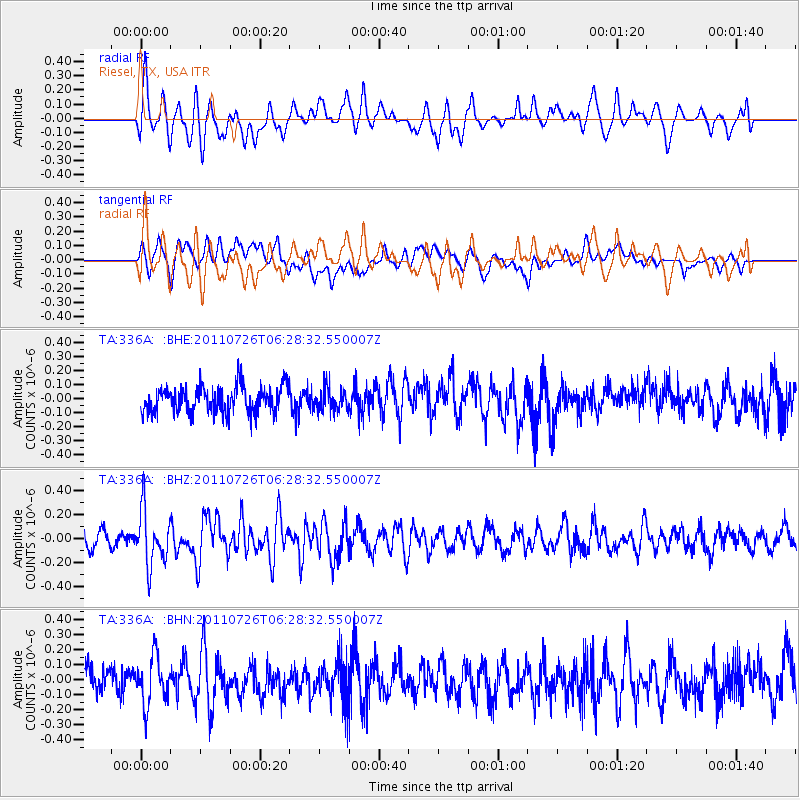
336A Riesel, TX, USA - Earthquake Result Viewer
*The percent match for this event was below the threshold and hence no stack was calculated.
| Earthquake location: |
Off East Coast Of Kamchatka |
| Earthquake latitude/longitude: |
53.0/159.8 |
| Earthquake time(UTC): |
2011/07/26 (207) 06:17:37 GMT |
| Earthquake Depth: |
33 km |
| Earthquake Magnitude: |
5.6 MW, 5.1 MS, 5.4 MB, 5.4 MW |
| Earthquake Catalog/Contributor: |
WHDF/NEIC |
|
| Network: |
TA USArray Transportable Network (new EarthScope stations) |
| Station: |
336A Riesel, TX, USA |
| Lat/Lon: |
31.39 N/96.84 W |
| Elevation: |
140 m |
|
| Distance: |
72.9 deg |
| Az: |
60.501 deg |
| Baz: |
322.031 deg |
| Ray Param: |
$rayparam |
*The percent match for this event was below the threshold and hence was not used in the summary stack. |
|
| Radial Match: |
66.06168 % |
| Radial Bump: |
400 |
| Transverse Match: |
51.778324 % |
| Transverse Bump: |
400 |
| SOD ConfigId: |
405110 |
| Insert Time: |
2011-12-29 07:13:46.557 +0000 |
| GWidth: |
2.5 |
| Max Bumps: |
400 |
| Tol: |
0.001 |
|
Signal To Noise
| Channel | StoN | STA | LTA |
| TA:336A: :BHZ:20110726T06:28:32.550007Z | 4.0788937 | 2.2909471E-7 | 5.6165895E-8 |
| TA:336A: :BHN:20110726T06:28:32.550007Z | 1.8218455 | 1.5980152E-7 | 8.7714085E-8 |
| TA:336A: :BHE:20110726T06:28:32.550007Z | 0.8608286 | 8.058146E-8 | 9.3609174E-8 |
| Arrivals |
| Ps | |
| PpPs | |
| PsPs/PpSs | |


