You are here: Home > Network List > TA - USArray Transportable Network (new EarthScope stations) Stations List
> Station K33A Hardington, NE, USA > Earthquake Result Viewer
K33A Hardington, NE, USA - Earthquake Result Viewer
| Earthquake location: |
Off East Coast Of Kamchatka |
| Earthquake latitude/longitude: |
53.0/159.8 |
| Earthquake time(UTC): |
2011/07/26 (207) 06:17:37 GMT |
| Earthquake Depth: |
33 km |
| Earthquake Magnitude: |
5.6 MW, 5.1 MS, 5.4 MB, 5.4 MW |
| Earthquake Catalog/Contributor: |
WHDF/NEIC |
|
| Network: |
TA USArray Transportable Network (new EarthScope stations) |
| Station: |
K33A Hardington, NE, USA |
| Lat/Lon: |
42.61 N/97.00 W |
| Elevation: |
507 m |
|
| Distance: |
64.2 deg |
| Az: |
52.977 deg |
| Baz: |
319.176 deg |
| Ray Param: |
0.059025444 |
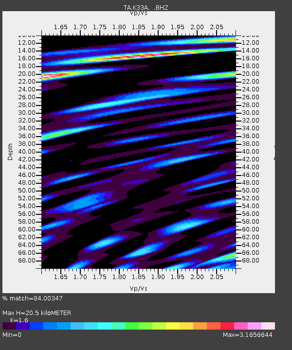
| Estimated Moho Depth: |
20.5 km |
| Estimated Crust Vp/Vs: |
1.60 |
| Assumed Crust Vp: |
6.498 km/s |
| Estimated Crust Vs: |
4.061 km/s |
| Estimated Crust Poisson's Ratio: |
0.18 |
|
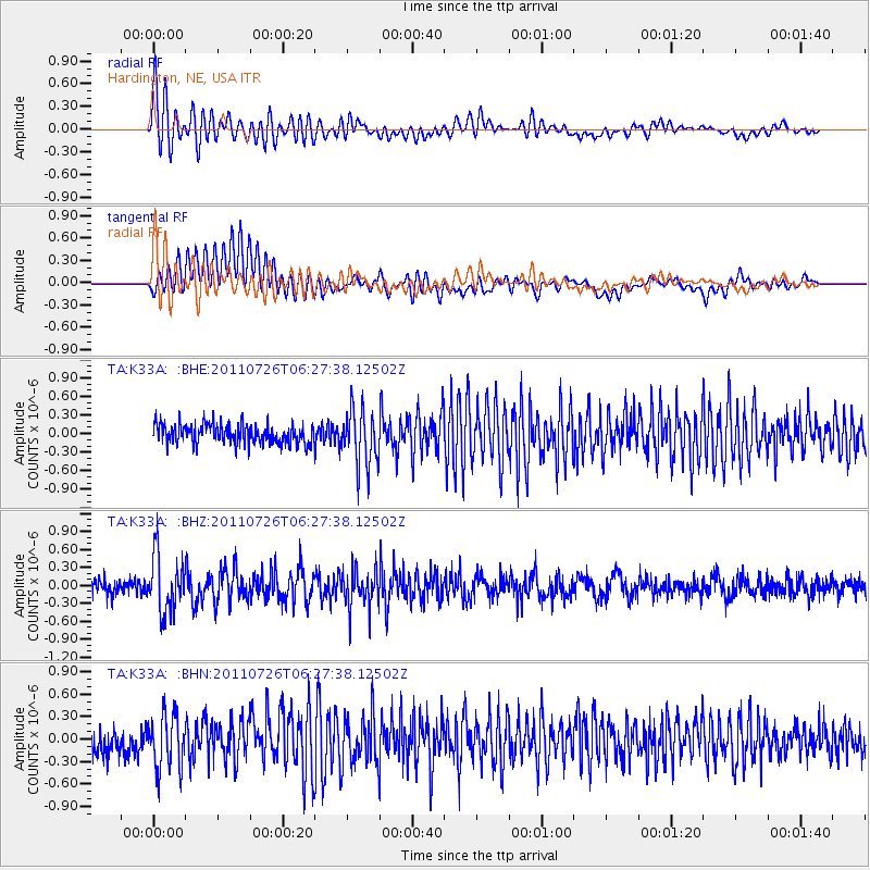
| Radial Match: |
84.00347 % |
| Radial Bump: |
400 |
| Transverse Match: |
73.84922 % |
| Transverse Bump: |
400 |
| SOD ConfigId: |
405110 |
| Insert Time: |
2011-12-29 07:20:18.245 +0000 |
| GWidth: |
2.5 |
| Max Bumps: |
400 |
| Tol: |
0.001 |
|
Signal To Noise
| Channel | StoN | STA | LTA |
| TA:K33A: :BHZ:20110726T06:27:38.12502Z | 3.8083231 | 4.694575E-7 | 1.2327145E-7 |
| TA:K33A: :BHN:20110726T06:27:38.12502Z | 2.4279225 | 3.721217E-7 | 1.5326754E-7 |
| TA:K33A: :BHE:20110726T06:27:38.12502Z | 2.8964002 | 4.5564647E-7 | 1.5731474E-7 |
| Arrivals |
| Ps | 2.0 SECOND |
| PpPs | 7.8 SECOND |
| PsPs/PpSs | 9.8 SECOND |


