You are here: Home > Network List > TA - USArray Transportable Network (new EarthScope stations) Stations List
> Station J34A George, IA, USA > Earthquake Result Viewer
J34A George, IA, USA - Earthquake Result Viewer
| Earthquake location: |
Off East Coast Of Kamchatka |
| Earthquake latitude/longitude: |
53.0/159.8 |
| Earthquake time(UTC): |
2011/07/26 (207) 06:17:37 GMT |
| Earthquake Depth: |
33 km |
| Earthquake Magnitude: |
5.6 MW, 5.1 MS, 5.4 MB, 5.4 MW |
| Earthquake Catalog/Contributor: |
WHDF/NEIC |
|
| Network: |
TA USArray Transportable Network (new EarthScope stations) |
| Station: |
J34A George, IA, USA |
| Lat/Lon: |
43.28 N/95.96 W |
| Elevation: |
432 m |
|
| Distance: |
64.2 deg |
| Az: |
51.84 deg |
| Baz: |
319.389 deg |
| Ray Param: |
0.059034888 |
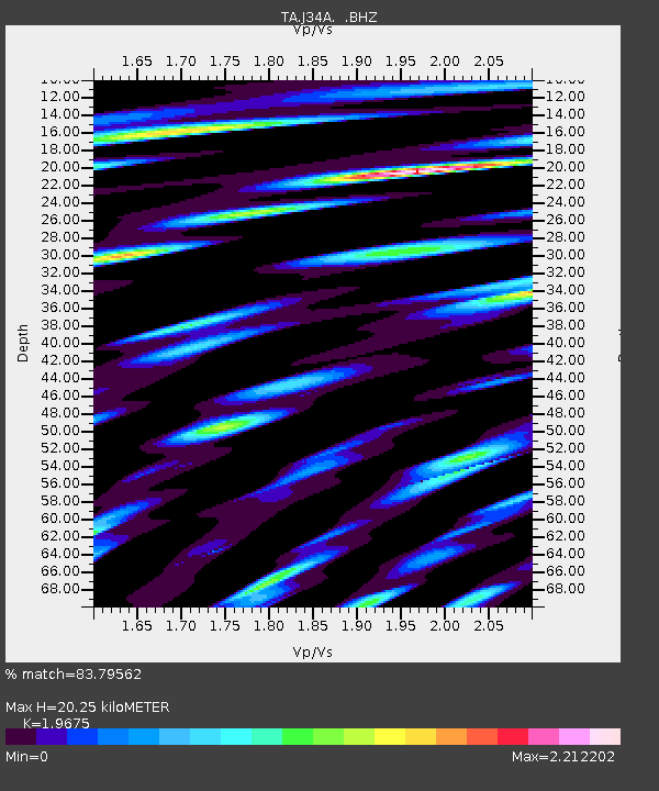
| Estimated Moho Depth: |
20.25 km |
| Estimated Crust Vp/Vs: |
1.97 |
| Assumed Crust Vp: |
6.53 km/s |
| Estimated Crust Vs: |
3.319 km/s |
| Estimated Crust Poisson's Ratio: |
0.33 |
|
| Radial Match: |
83.79562 % |
| Radial Bump: |
400 |
| Transverse Match: |
67.869865 % |
| Transverse Bump: |
400 |
| SOD ConfigId: |
405110 |
| Insert Time: |
2011-12-29 07:21:02.491 +0000 |
| GWidth: |
2.5 |
| Max Bumps: |
400 |
| Tol: |
0.001 |
|
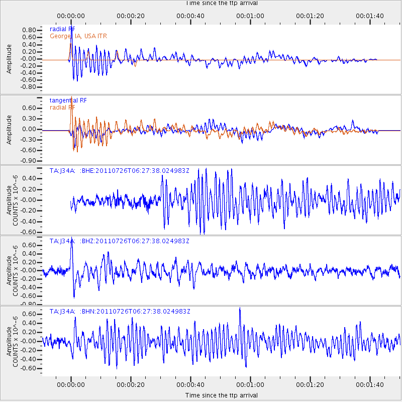
Signal To Noise
| Channel | StoN | STA | LTA |
| TA:J34A: :BHZ:20110726T06:27:38.024983Z | 5.929924 | 3.1825996E-7 | 5.3670156E-8 |
| TA:J34A: :BHN:20110726T06:27:38.024983Z | 2.5487347 | 2.0962132E-7 | 8.224524E-8 |
| TA:J34A: :BHE:20110726T06:27:38.024983Z | 3.3755932 | 2.3578396E-7 | 6.984964E-8 |
| Arrivals |
| Ps | 3.1 SECOND |
| PpPs | 8.8 SECOND |
| PsPs/PpSs | 12 SECOND |


