You are here: Home > Network List > TA - USArray Transportable Network (new EarthScope stations) Stations List
> Station C39A Grand Marais, MN, USA > Earthquake Result Viewer
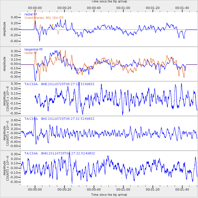
C39A Grand Marais, MN, USA - Earthquake Result Viewer
*The percent match for this event was below the threshold and hence no stack was calculated.
| Earthquake location: |
Off East Coast Of Kamchatka |
| Earthquake latitude/longitude: |
53.0/159.8 |
| Earthquake time(UTC): |
2011/07/26 (207) 06:17:37 GMT |
| Earthquake Depth: |
33 km |
| Earthquake Magnitude: |
5.6 MW, 5.1 MS, 5.4 MB, 5.4 MW |
| Earthquake Catalog/Contributor: |
WHDF/NEIC |
|
| Network: |
TA USArray Transportable Network (new EarthScope stations) |
| Station: |
C39A Grand Marais, MN, USA |
| Lat/Lon: |
47.82 N/90.13 W |
| Elevation: |
341 m |
|
| Distance: |
63.3 deg |
| Az: |
45.096 deg |
| Baz: |
320.557 deg |
| Ray Param: |
$rayparam |
*The percent match for this event was below the threshold and hence was not used in the summary stack. |
|
| Radial Match: |
53.808437 % |
| Radial Bump: |
400 |
| Transverse Match: |
67.918 % |
| Transverse Bump: |
400 |
| SOD ConfigId: |
405110 |
| Insert Time: |
2011-12-29 07:24:32.604 +0000 |
| GWidth: |
2.5 |
| Max Bumps: |
400 |
| Tol: |
0.001 |
|
Signal To Noise
| Channel | StoN | STA | LTA |
| TA:C39A: :BHZ:20110726T06:27:32.524983Z | 3.2460246 | 3.1552975E-7 | 9.7204975E-8 |
| TA:C39A: :BHN:20110726T06:27:32.524983Z | 0.8108046 | 7.874736E-8 | 9.7122495E-8 |
| TA:C39A: :BHE:20110726T06:27:32.524983Z | 1.8474174 | 1.8020597E-7 | 9.754481E-8 |
| Arrivals |
| Ps | |
| PpPs | |
| PsPs/PpSs | |


