You are here: Home > Network List > TA - USArray Transportable Network (new EarthScope stations) Stations List
> Station Z45A Winona, MS, USA > Earthquake Result Viewer
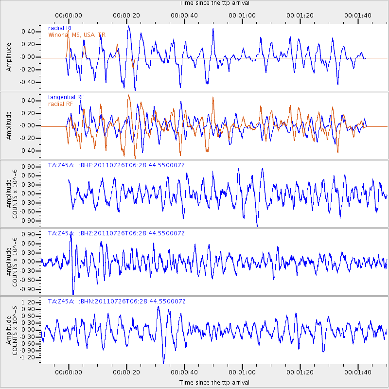
Z45A Winona, MS, USA - Earthquake Result Viewer
*The percent match for this event was below the threshold and hence no stack was calculated.
| Earthquake location: |
Off East Coast Of Kamchatka |
| Earthquake latitude/longitude: |
53.0/159.8 |
| Earthquake time(UTC): |
2011/07/26 (207) 06:17:37 GMT |
| Earthquake Depth: |
33 km |
| Earthquake Magnitude: |
5.6 MW, 5.1 MS, 5.4 MB, 5.4 MW |
| Earthquake Catalog/Contributor: |
WHDF/NEIC |
|
| Network: |
TA USArray Transportable Network (new EarthScope stations) |
| Station: |
Z45A Winona, MS, USA |
| Lat/Lon: |
33.37 N/89.69 W |
| Elevation: |
113 m |
|
| Distance: |
75.0 deg |
| Az: |
54.233 deg |
| Baz: |
324.114 deg |
| Ray Param: |
$rayparam |
*The percent match for this event was below the threshold and hence was not used in the summary stack. |
|
| Radial Match: |
55.08243 % |
| Radial Bump: |
400 |
| Transverse Match: |
54.14354 % |
| Transverse Bump: |
400 |
| SOD ConfigId: |
405110 |
| Insert Time: |
2011-12-29 07:34:58.210 +0000 |
| GWidth: |
2.5 |
| Max Bumps: |
400 |
| Tol: |
0.001 |
|
Signal To Noise
| Channel | StoN | STA | LTA |
| TA:Z45A: :BHZ:20110726T06:28:44.550007Z | 3.810422 | 4.9346835E-7 | 1.2950491E-7 |
| TA:Z45A: :BHN:20110726T06:28:44.550007Z | 0.96150273 | 2.91583E-7 | 3.032576E-7 |
| TA:Z45A: :BHE:20110726T06:28:44.550007Z | 1.1157979 | 2.980022E-7 | 2.6707542E-7 |
| Arrivals |
| Ps | |
| PpPs | |
| PsPs/PpSs | |


