You are here: Home > Network List > TA - USArray Transportable Network (new EarthScope stations) Stations List
> Station U41A Viola, AR, USA > Earthquake Result Viewer
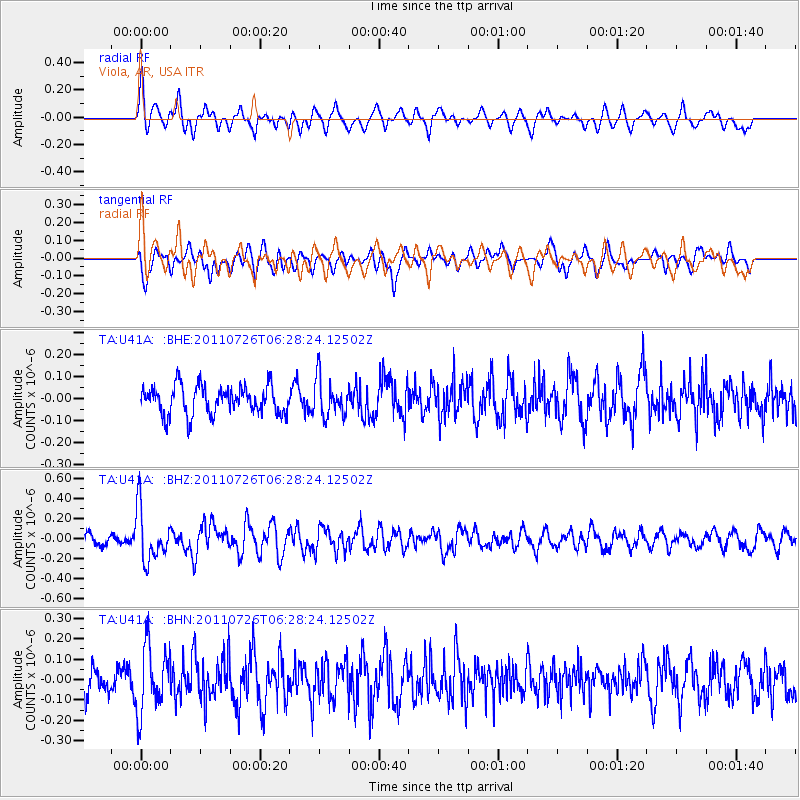
U41A Viola, AR, USA - Earthquake Result Viewer
*The percent match for this event was below the threshold and hence no stack was calculated.
| Earthquake location: |
Off East Coast Of Kamchatka |
| Earthquake latitude/longitude: |
53.0/159.8 |
| Earthquake time(UTC): |
2011/07/26 (207) 06:17:37 GMT |
| Earthquake Depth: |
33 km |
| Earthquake Magnitude: |
5.6 MW, 5.1 MS, 5.4 MB, 5.4 MW |
| Earthquake Catalog/Contributor: |
WHDF/NEIC |
|
| Network: |
TA USArray Transportable Network (new EarthScope stations) |
| Station: |
U41A Viola, AR, USA |
| Lat/Lon: |
36.34 N/91.92 W |
| Elevation: |
300 m |
|
| Distance: |
71.5 deg |
| Az: |
53.926 deg |
| Baz: |
322.757 deg |
| Ray Param: |
$rayparam |
*The percent match for this event was below the threshold and hence was not used in the summary stack. |
|
| Radial Match: |
53.206005 % |
| Radial Bump: |
397 |
| Transverse Match: |
61.603745 % |
| Transverse Bump: |
400 |
| SOD ConfigId: |
405110 |
| Insert Time: |
2011-12-29 07:38:31.728 +0000 |
| GWidth: |
2.5 |
| Max Bumps: |
400 |
| Tol: |
0.001 |
|
Signal To Noise
| Channel | StoN | STA | LTA |
| TA:U41A: :BHZ:20110726T06:28:24.12502Z | 5.41092 | 2.5858895E-7 | 4.77902E-8 |
| TA:U41A: :BHN:20110726T06:28:24.12502Z | 2.2915754 | 1.6075974E-7 | 7.0152495E-8 |
| TA:U41A: :BHE:20110726T06:28:24.12502Z | 1.3512027 | 8.67099E-8 | 6.417239E-8 |
| Arrivals |
| Ps | |
| PpPs | |
| PsPs/PpSs | |


