You are here: Home > Network List > NE - New England Seismic Network Stations List
> Station EMMW Machias, ME, USA > Earthquake Result Viewer
EMMW Machias, ME, USA - Earthquake Result Viewer
| Earthquake location: |
Near Coast Of Northern Chile |
| Earthquake latitude/longitude: |
-19.6/-70.5 |
| Earthquake time(UTC): |
2014/04/02 (092) 00:04:54 GMT |
| Earthquake Depth: |
34 km |
| Earthquake Magnitude: |
5.5 MB |
| Earthquake Catalog/Contributor: |
NEIC PDE/NEIC COMCAT |
|
| Network: |
NE New England Seismic Network |
| Station: |
EMMW Machias, ME, USA |
| Lat/Lon: |
44.71 N/67.46 W |
| Elevation: |
35 m |
|
| Distance: |
64.0 deg |
| Az: |
2.411 deg |
| Baz: |
183.189 deg |
| Ray Param: |
0.059120696 |
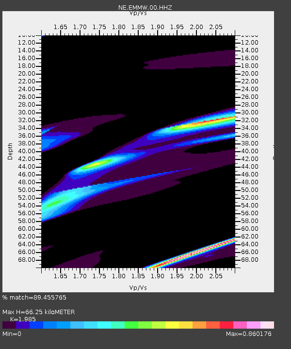
| Estimated Moho Depth: |
66.25 km |
| Estimated Crust Vp/Vs: |
1.99 |
| Assumed Crust Vp: |
6.419 km/s |
| Estimated Crust Vs: |
3.234 km/s |
| Estimated Crust Poisson's Ratio: |
0.33 |
|
| Radial Match: |
89.455765 % |
| Radial Bump: |
400 |
| Transverse Match: |
57.383133 % |
| Transverse Bump: |
177 |
| SOD ConfigId: |
3390531 |
| Insert Time: |
2019-04-11 00:08:05.776 +0000 |
| GWidth: |
2.5 |
| Max Bumps: |
400 |
| Tol: |
0.001 |
|
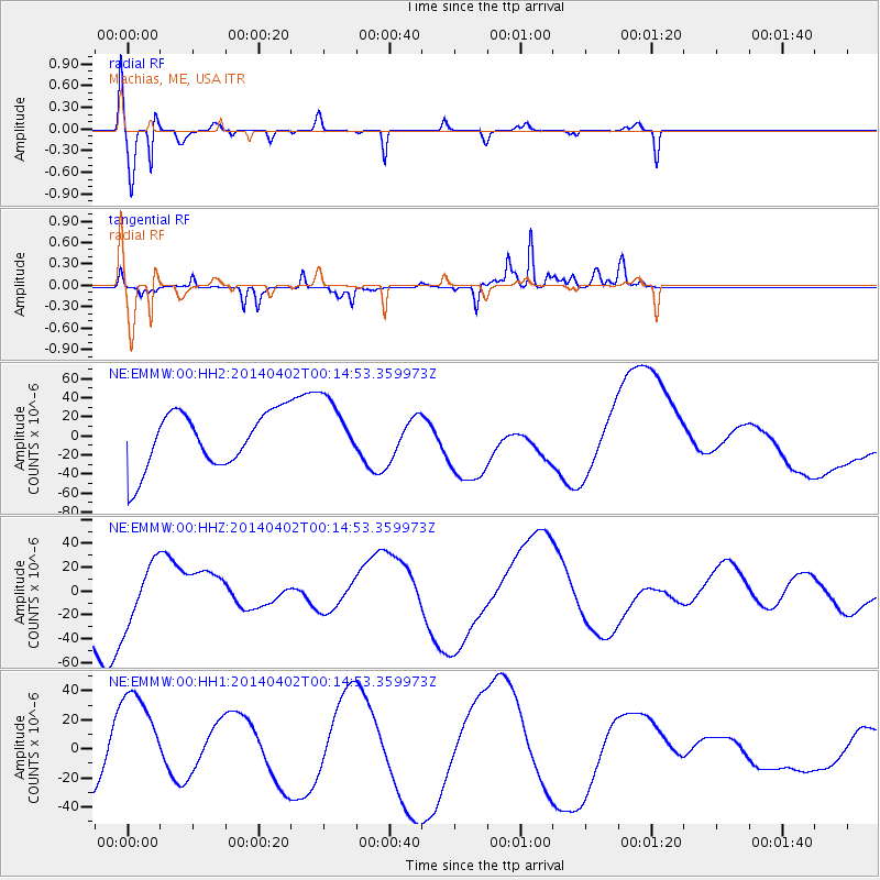
Signal To Noise
| Channel | StoN | STA | LTA |
| NE:EMMW:00:HHZ:20140402T00:14:53.359973Z | 0.6238327 | 2.5104848E-5 | 4.0242918E-5 |
| NE:EMMW:00:HH1:20140402T00:14:53.359973Z | 1.421336 | 3.499988E-5 | 2.4624636E-5 |
| NE:EMMW:00:HH2:20140402T00:14:53.359973Z | 0.9228987 | 2.5282485E-5 | 2.7394648E-5 |
| Arrivals |
| Ps | 11 SECOND |
| PpPs | 30 SECOND |
| PsPs/PpSs | 40 SECOND |


