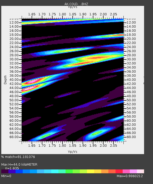
COLD Coldfoot Broadband - Earthquake Result Viewer

Earthquake location: Gulf Of California
Earthquake latitude/longitude: 25.1/-109.5
Earthquake time(UTC): 2011/07/26 (207) 17:44:20 GMT
Earthquake Depth: 12 km
Earthquake Magnitude: 5.6 MB, 5.8 MS, 6.0 MW, 6.0 MW
Earthquake Catalog/Contributor: WHDF/NEIC
Network: AK Alaska Regional Network
Station: COLD Coldfoot Broadband
Lat/Lon: 67.23 N/150.20 W
Elevation: 377 m
Distance: 49.0 deg
Az: 340.349 deg
Baz: 128.445 deg
Ray Param: 0.06899233
Estimated Moho Depth: 44.0 km
Estimated Crust Vp/Vs: 1.63
Assumed Crust Vp: 6.577 km/s
Estimated Crust Vs: 4.022 km/s
Estimated Crust Poisson's Ratio: 0.20
Radial Match: 91.181076 %
Radial Bump: 400
Transverse Match: 70.87716 %
Transverse Bump: 400
SOD ConfigId: 405110
Insert Time: 2011-12-29 07:50:28.678 +0000
GWidth: 2.5
Max Bumps: 400
Tol: 0.001

Signal To Noise

ChannelStoNSTALTA
AK:COLD: :BHZ:20110726T17:52:35.688014Z12.8587385.280131E-74.106259E-8
AK:COLD: :BHN:20110726T17:52:35.688014Z3.20731952.0681163E-76.448114E-8
AK:COLD: :BHE:20110726T17:52:35.688014Z5.33078051.9497432E-73.657519E-8
Arrivals
Ps4.5 SECOND
PpPs16 SECOND
PsPs/PpSs21 SECOND