You are here: Home > Network List > IM - International Miscellaneous Stations Stations List
> Station IL31 ILAR Array, Eilson, AK, USA > Earthquake Result Viewer
IL31 ILAR Array, Eilson, AK, USA - Earthquake Result Viewer
| Earthquake location: |
Gulf Of California |
| Earthquake latitude/longitude: |
25.1/-109.5 |
| Earthquake time(UTC): |
2011/07/26 (207) 17:44:20 GMT |
| Earthquake Depth: |
12 km |
| Earthquake Magnitude: |
5.6 MB, 5.8 MS, 6.0 MW, 6.0 MW |
| Earthquake Catalog/Contributor: |
WHDF/NEIC |
|
| Network: |
IM International Miscellaneous Stations |
| Station: |
IL31 ILAR Array, Eilson, AK, USA |
| Lat/Lon: |
64.77 N/146.89 W |
| Elevation: |
419 m |
|
| Distance: |
46.4 deg |
| Az: |
338.941 deg |
| Baz: |
130.522 deg |
| Ray Param: |
0.07068221 |
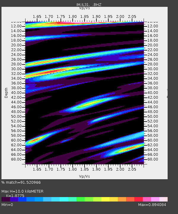
| Estimated Moho Depth: |
10.0 km |
| Estimated Crust Vp/Vs: |
1.88 |
| Assumed Crust Vp: |
6.566 km/s |
| Estimated Crust Vs: |
3.497 km/s |
| Estimated Crust Poisson's Ratio: |
0.30 |
|
| Radial Match: |
91.520966 % |
| Radial Bump: |
400 |
| Transverse Match: |
86.14853 % |
| Transverse Bump: |
400 |
| SOD ConfigId: |
405110 |
| Insert Time: |
2011-12-29 07:54:51.925 +0000 |
| GWidth: |
2.5 |
| Max Bumps: |
400 |
| Tol: |
0.001 |
|

Signal To Noise
| Channel | StoN | STA | LTA |
| IM:IL31: :BHZ:20110726T17:52:15.425013Z | 9.646742 | 1.988454E-8 | 2.06127E-9 |
| IM:IL31: :BHN:20110726T17:52:15.425013Z | 5.073534 | 8.818195E-9 | 1.7380773E-9 |
| IM:IL31: :BHE:20110726T17:52:15.425013Z | 3.0124679 | 5.308397E-9 | 1.7621422E-9 |
| Arrivals |
| Ps | 1.4 SECOND |
| PpPs | 4.1 SECOND |
| PsPs/PpSs | 5.5 SECOND |


