You are here: Home > Network List > NE - New England Seismic Network Stations List
> Station TRY Troy, NY > Earthquake Result Viewer
TRY Troy, NY - Earthquake Result Viewer
| Earthquake location: |
Gulf Of California |
| Earthquake latitude/longitude: |
25.1/-109.5 |
| Earthquake time(UTC): |
2011/07/26 (207) 17:44:20 GMT |
| Earthquake Depth: |
12 km |
| Earthquake Magnitude: |
5.6 MB, 5.8 MS, 6.0 MW, 6.0 MW |
| Earthquake Catalog/Contributor: |
WHDF/NEIC |
|
| Network: |
NE New England Seismic Network |
| Station: |
TRY Troy, NY |
| Lat/Lon: |
42.73 N/73.67 W |
| Elevation: |
131 m |
|
| Distance: |
34.2 deg |
| Az: |
50.088 deg |
| Baz: |
250.705 deg |
| Ray Param: |
0.07783217 |
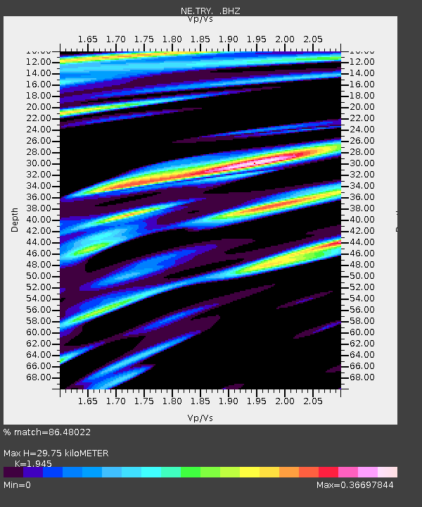
| Estimated Moho Depth: |
29.75 km |
| Estimated Crust Vp/Vs: |
1.95 |
| Assumed Crust Vp: |
6.419 km/s |
| Estimated Crust Vs: |
3.3 km/s |
| Estimated Crust Poisson's Ratio: |
0.32 |
|
| Radial Match: |
86.48022 % |
| Radial Bump: |
317 |
| Transverse Match: |
64.754974 % |
| Transverse Bump: |
400 |
| SOD ConfigId: |
405110 |
| Insert Time: |
2011-12-29 07:57:40.641 +0000 |
| GWidth: |
2.5 |
| Max Bumps: |
400 |
| Tol: |
0.001 |
|

Signal To Noise
| Channel | StoN | STA | LTA |
| NE:TRY: :BHZ:20110726T17:50:35.249995Z | 4.9888673 | 4.9880055E-7 | 9.998273E-8 |
| NE:TRY: :BHN:20110726T17:50:35.249995Z | 0.9851765 | 1.15142235E-7 | 1.1687473E-7 |
| NE:TRY: :BHE:20110726T17:50:35.249995Z | 3.1352813 | 3.912895E-7 | 1.2480204E-7 |
| Arrivals |
| Ps | 4.7 SECOND |
| PpPs | 13 SECOND |
| PsPs/PpSs | 17 SECOND |


