You are here: Home > Network List > CI - Caltech Regional Seismic Network Stations List
> Station SWS Sam W. Stewart, Westmorland, CA, USA > Earthquake Result Viewer
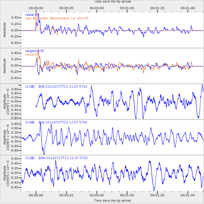
SWS Sam W. Stewart, Westmorland, CA, USA - Earthquake Result Viewer
*The percent match for this event was below the threshold and hence no stack was calculated.
| Earthquake location: |
Northern Mid-Atlantic Ridge |
| Earthquake latitude/longitude: |
10.8/-43.4 |
| Earthquake time(UTC): |
2011/07/27 (208) 23:00:30 GMT |
| Earthquake Depth: |
10 km |
| Earthquake Magnitude: |
5.6 MB, 5.6 MS, 6.0 MW, 5.9 MW |
| Earthquake Catalog/Contributor: |
WHDF/NEIC |
|
| Network: |
CI Caltech Regional Seismic Network |
| Station: |
SWS Sam W. Stewart, Westmorland, CA, USA |
| Lat/Lon: |
32.94 N/115.80 W |
| Elevation: |
140 m |
|
| Distance: |
69.5 deg |
| Az: |
301.146 deg |
| Baz: |
90.257 deg |
| Ray Param: |
$rayparam |
*The percent match for this event was below the threshold and hence was not used in the summary stack. |
|
| Radial Match: |
79.101036 % |
| Radial Bump: |
381 |
| Transverse Match: |
65.12457 % |
| Transverse Bump: |
400 |
| SOD ConfigId: |
405110 |
| Insert Time: |
2011-12-29 08:11:31.533 +0000 |
| GWidth: |
2.5 |
| Max Bumps: |
400 |
| Tol: |
0.001 |
|
Signal To Noise
| Channel | StoN | STA | LTA |
| CI:SWS: :BHZ:20110727T23:11:07.570Z | 2.9206026 | 4.622871E-7 | 1.5828483E-7 |
| CI:SWS: :BHN:20110727T23:11:07.570Z | 0.6010731 | 1.2556966E-7 | 2.0890911E-7 |
| CI:SWS: :BHE:20110727T23:11:07.570Z | 1.3016714 | 2.1440222E-7 | 1.6471301E-7 |
| Arrivals |
| Ps | |
| PpPs | |
| PsPs/PpSs | |


