You are here: Home > Network List > CI - Caltech Regional Seismic Network Stations List
> Station MPP McPhearson Peak > Earthquake Result Viewer
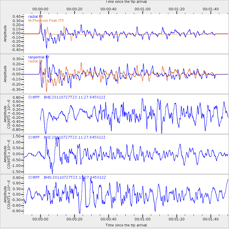
MPP McPhearson Peak - Earthquake Result Viewer
*The percent match for this event was below the threshold and hence no stack was calculated.
| Earthquake location: |
Northern Mid-Atlantic Ridge |
| Earthquake latitude/longitude: |
10.8/-43.4 |
| Earthquake time(UTC): |
2011/07/27 (208) 23:00:30 GMT |
| Earthquake Depth: |
10 km |
| Earthquake Magnitude: |
5.6 MB, 5.6 MS, 6.0 MW, 5.9 MW |
| Earthquake Catalog/Contributor: |
WHDF/NEIC |
|
| Network: |
CI Caltech Regional Seismic Network |
| Station: |
MPP McPhearson Peak |
| Lat/Lon: |
34.89 N/119.81 W |
| Elevation: |
1739 m |
|
| Distance: |
72.8 deg |
| Az: |
303.23 deg |
| Baz: |
88.698 deg |
| Ray Param: |
$rayparam |
*The percent match for this event was below the threshold and hence was not used in the summary stack. |
|
| Radial Match: |
70.19303 % |
| Radial Bump: |
400 |
| Transverse Match: |
66.080315 % |
| Transverse Bump: |
400 |
| SOD ConfigId: |
405110 |
| Insert Time: |
2011-12-29 08:12:55.734 +0000 |
| GWidth: |
2.5 |
| Max Bumps: |
400 |
| Tol: |
0.001 |
|
Signal To Noise
| Channel | StoN | STA | LTA |
| CI:MPP: :BHZ:20110727T23:11:27.645012Z | 1.3508902 | 4.4508874E-7 | 3.2947813E-7 |
| CI:MPP: :BHN:20110727T23:11:27.645012Z | 0.60920584 | 2.0380834E-7 | 3.345476E-7 |
| CI:MPP: :BHE:20110727T23:11:27.645012Z | 0.8508988 | 2.3265706E-7 | 2.7342506E-7 |
| Arrivals |
| Ps | |
| PpPs | |
| PsPs/PpSs | |


