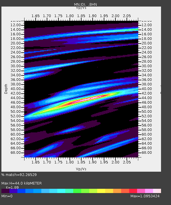
IDI Anogia, Greece - Earthquake Result Viewer
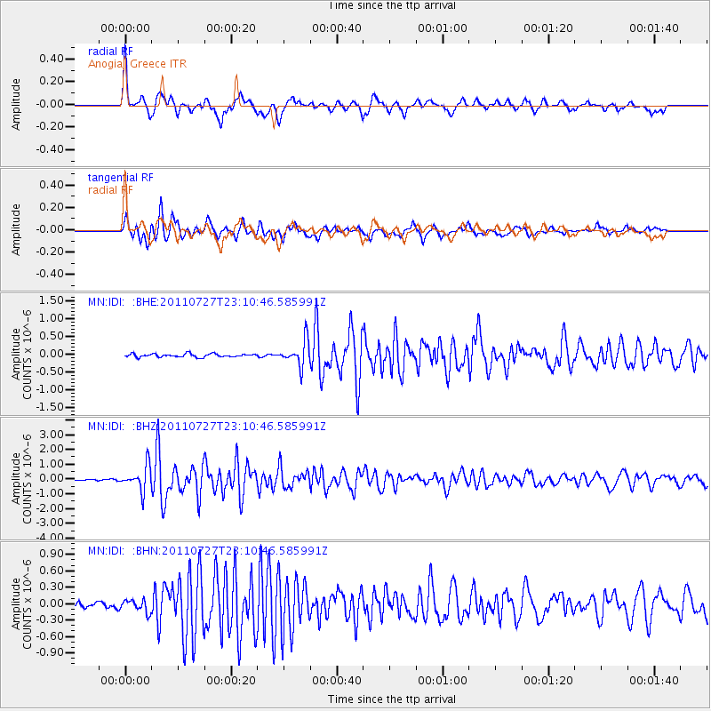
Earthquake location: Northern Mid-Atlantic Ridge
Earthquake latitude/longitude: 10.8/-43.4
Earthquake time(UTC): 2011/07/27 (208) 23:00:30 GMT
Earthquake Depth: 10 km
Earthquake Magnitude: 5.6 MB, 5.6 MS, 6.0 MW, 5.9 MW
Earthquake Catalog/Contributor: WHDF/NEIC
Network: MN MEDNET Project
Station: IDI Anogia, Greece
Lat/Lon: 35.29 N/24.89 E
Elevation: 750 m
Distance: 66.1 deg
Az: 56.205 deg
Baz: 266.442 deg
Ray Param: 0.05781089
Estimated Moho Depth: 44.0 km
Estimated Crust Vp/Vs: 1.89
Assumed Crust Vp: 5.627 km/s
Estimated Crust Vs: 2.977 km/s
Estimated Crust Poisson's Ratio: 0.31
Radial Match: 92.26529 %
Radial Bump: 400
Transverse Match: 90.28141 %
Transverse Bump: 400
SOD ConfigId: 405110
Insert Time: 2011-12-29 08:22:08.617 +0000
GWidth: 2.5
Max Bumps: 400
Tol: 0.001

Signal To Noise

ChannelStoNSTALTA
MN:IDI: :BHZ:20110727T23:10:46.585991Z9.71126658.3766406E-78.625693E-8
MN:IDI: :BHN:20110727T23:10:46.585991Z2.25861241.1198155E-74.9579796E-8
MN:IDI: :BHE:20110727T23:10:46.585991Z7.99947743.5594684E-74.449626E-8
Arrivals
Ps7.2 SECOND
PpPs22 SECOND
PsPs/PpSs29 SECOND