TIP Timpagrande, Italy - Earthquake Result Viewer
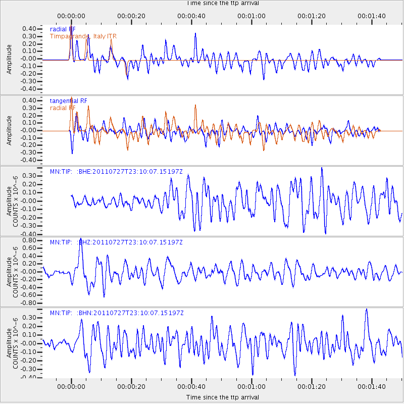
Earthquake location: Northern Mid-Atlantic Ridge
Earthquake latitude/longitude: 10.8/-43.4
Earthquake time(UTC): 2011/07/27 (208) 23:00:30 GMT
Earthquake Depth: 10 km
Earthquake Magnitude: 5.6 MB, 5.6 MS, 6.0 MW, 5.9 MW
Earthquake Catalog/Contributor: WHDF/NEIC
Network: MN MEDNET Project
Station: TIP Timpagrande, Italy
Lat/Lon: 39.18 N/16.76 E
Elevation: 789 m
Distance: 60.2 deg
Az: 50.986 deg
Baz: 259.173 deg
Ray Param: 0.061700646
Estimated Moho Depth: 12.25 km
Estimated Crust Vp/Vs: 2.02
Assumed Crust Vp: 6.1 km/s
Estimated Crust Vs: 3.027 km/s
Estimated Crust Poisson's Ratio: 0.34
Radial Match: 81.23817 %
Radial Bump: 400
Transverse Match: 76.76698 %
Transverse Bump: 400
SOD ConfigId: 405110
Insert Time: 2011-12-29 08:22:34.325 +0000
GWidth: 2.5
Max Bumps: 400
Tol: 0.001

Signal To Noise

ChannelStoNSTALTA
MN:TIP: :BHZ:20110727T23:10:07.15197Z5.47956943.6114656E-76.5907834E-8
MN:TIP: :BHN:20110727T23:10:07.15197Z2.30439691.2582322E-75.4601372E-8
MN:TIP: :BHE:20110727T23:10:07.15197Z2.80142641.2002917E-74.2845734E-8
Arrivals
Ps2.1 SECOND
PpPs5.8 SECOND
PsPs/PpSs8.0 SECOND