You are here: Home > Network List > TA - USArray Transportable Network (new EarthScope stations) Stations List
> Station J46A Howard City, MI, USA > Earthquake Result Viewer
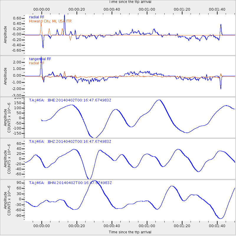
J46A Howard City, MI, USA - Earthquake Result Viewer
*The percent match for this event was below the threshold and hence no stack was calculated.
| Earthquake location: |
Near Coast Of Northern Chile |
| Earthquake latitude/longitude: |
-19.6/-70.8 |
| Earthquake time(UTC): |
2014/04/02 (092) 00:06:44 GMT |
| Earthquake Depth: |
10 km |
| Earthquake Magnitude: |
5.7 MB |
| Earthquake Catalog/Contributor: |
NEIC PDE/NEIC COMCAT |
|
| Network: |
TA USArray Transportable Network (new EarthScope stations) |
| Station: |
J46A Howard City, MI, USA |
| Lat/Lon: |
43.35 N/85.65 W |
| Elevation: |
275 m |
|
| Distance: |
64.1 deg |
| Az: |
348.017 deg |
| Baz: |
164.439 deg |
| Ray Param: |
$rayparam |
*The percent match for this event was below the threshold and hence was not used in the summary stack. |
|
| Radial Match: |
69.61013 % |
| Radial Bump: |
400 |
| Transverse Match: |
26.601717 % |
| Transverse Bump: |
400 |
| SOD ConfigId: |
3390531 |
| Insert Time: |
2019-04-11 00:16:28.508 +0000 |
| GWidth: |
2.5 |
| Max Bumps: |
400 |
| Tol: |
0.001 |
|
Signal To Noise
| Channel | StoN | STA | LTA |
| TA:J46A: :BHZ:20140402T00:16:47.674983Z | 1.4832377 | 2.4279632E-5 | 1.6369348E-5 |
| TA:J46A: :BHN:20140402T00:16:47.674983Z | 1.102391 | 2.965283E-5 | 2.689865E-5 |
| TA:J46A: :BHE:20140402T00:16:47.674983Z | 3.7978067 | 2.2497466E-4 | 5.923805E-5 |
| Arrivals |
| Ps | |
| PpPs | |
| PsPs/PpSs | |


