You are here: Home > Network List > TA - USArray Transportable Network (new EarthScope stations) Stations List
> Station Q24A Divide, CO, USA > Earthquake Result Viewer
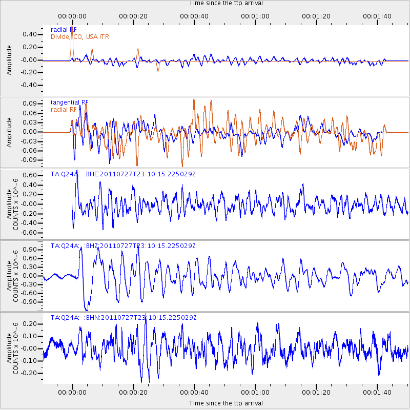
Q24A Divide, CO, USA - Earthquake Result Viewer
*The percent match for this event was below the threshold and hence no stack was calculated.
| Earthquake location: |
Northern Mid-Atlantic Ridge |
| Earthquake latitude/longitude: |
10.8/-43.4 |
| Earthquake time(UTC): |
2011/07/27 (208) 23:00:30 GMT |
| Earthquake Depth: |
10 km |
| Earthquake Magnitude: |
5.6 MB, 5.6 MS, 6.0 MW, 5.9 MW |
| Earthquake Catalog/Contributor: |
WHDF/NEIC |
|
| Network: |
TA USArray Transportable Network (new EarthScope stations) |
| Station: |
Q24A Divide, CO, USA |
| Lat/Lon: |
38.96 N/105.15 W |
| Elevation: |
2775 m |
|
| Distance: |
61.4 deg |
| Az: |
308.518 deg |
| Baz: |
99.577 deg |
| Ray Param: |
$rayparam |
*The percent match for this event was below the threshold and hence was not used in the summary stack. |
|
| Radial Match: |
46.49459 % |
| Radial Bump: |
400 |
| Transverse Match: |
56.13098 % |
| Transverse Bump: |
400 |
| SOD ConfigId: |
405110 |
| Insert Time: |
2011-12-29 08:49:31.298 +0000 |
| GWidth: |
2.5 |
| Max Bumps: |
400 |
| Tol: |
0.001 |
|
Signal To Noise
| Channel | StoN | STA | LTA |
| TA:Q24A: :BHZ:20110727T23:10:15.225029Z | 8.76476 | 6.085563E-7 | 6.943217E-8 |
| TA:Q24A: :BHN:20110727T23:10:15.225029Z | 1.0611639 | 1.0200179E-7 | 9.6122555E-8 |
| TA:Q24A: :BHE:20110727T23:10:15.225029Z | 0.7721172 | 1.7245684E-7 | 2.2335577E-7 |
| Arrivals |
| Ps | |
| PpPs | |
| PsPs/PpSs | |


