You are here: Home > Network List > TA - USArray Transportable Network (new EarthScope stations) Stations List
> Station MDND Maddock, ND, USA > Earthquake Result Viewer
MDND Maddock, ND, USA - Earthquake Result Viewer
| Earthquake location: |
Northern Mid-Atlantic Ridge |
| Earthquake latitude/longitude: |
10.8/-43.4 |
| Earthquake time(UTC): |
2011/07/27 (208) 23:00:30 GMT |
| Earthquake Depth: |
10 km |
| Earthquake Magnitude: |
5.6 MB, 5.6 MS, 6.0 MW, 5.9 MW |
| Earthquake Catalog/Contributor: |
WHDF/NEIC |
|
| Network: |
TA USArray Transportable Network (new EarthScope stations) |
| Station: |
MDND Maddock, ND, USA |
| Lat/Lon: |
47.85 N/99.60 W |
| Elevation: |
479 m |
|
| Distance: |
59.6 deg |
| Az: |
319.544 deg |
| Baz: |
108.831 deg |
| Ray Param: |
0.062065504 |
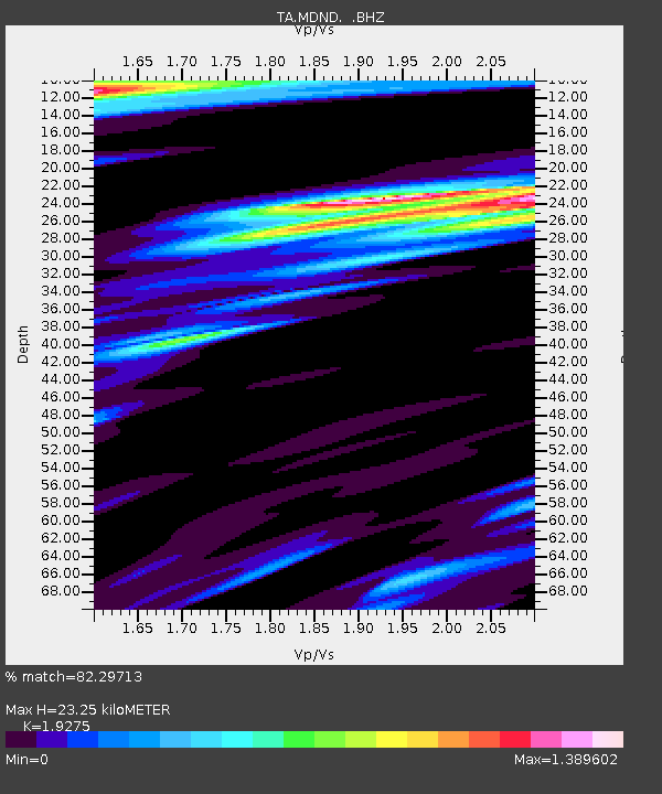
| Estimated Moho Depth: |
23.25 km |
| Estimated Crust Vp/Vs: |
1.93 |
| Assumed Crust Vp: |
6.53 km/s |
| Estimated Crust Vs: |
3.388 km/s |
| Estimated Crust Poisson's Ratio: |
0.32 |
|
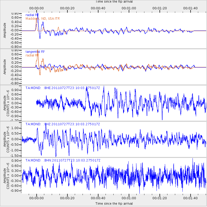
| Radial Match: |
82.29713 % |
| Radial Bump: |
400 |
| Transverse Match: |
52.321995 % |
| Transverse Bump: |
400 |
| SOD ConfigId: |
405110 |
| Insert Time: |
2011-12-29 08:49:56.367 +0000 |
| GWidth: |
2.5 |
| Max Bumps: |
400 |
| Tol: |
0.001 |
|
Signal To Noise
| Channel | StoN | STA | LTA |
| TA:MDND: :BHZ:20110727T23:10:03.275017Z | 5.3244905 | 6.738054E-7 | 1.2654833E-7 |
| TA:MDND: :BHN:20110727T23:10:03.275017Z | 1.2640619 | 3.169332E-7 | 2.50726E-7 |
| TA:MDND: :BHE:20110727T23:10:03.275017Z | 2.3843894 | 4.911225E-7 | 2.059741E-7 |
| Arrivals |
| Ps | 3.5 SECOND |
| PpPs | 10.0 SECOND |
| PsPs/PpSs | 13 SECOND |


