You are here: Home > Network List > TA - USArray Transportable Network (new EarthScope stations) Stations List
> Station O32A Brockman Farm, Red Cloud, NE, USA > Earthquake Result Viewer
O32A Brockman Farm, Red Cloud, NE, USA - Earthquake Result Viewer

| Earthquake location: |
Northern Mid-Atlantic Ridge |
| Earthquake latitude/longitude: |
10.8/-43.4 |
| Earthquake time(UTC): |
2011/07/27 (208) 23:00:30 GMT |
| Earthquake Depth: |
10 km |
| Earthquake Magnitude: |
5.6 MB, 5.6 MS, 6.0 MW, 5.9 MW |
| Earthquake Catalog/Contributor: |
WHDF/NEIC |
|
| Network: |
TA USArray Transportable Network (new EarthScope stations) |
| Station: |
O32A Brockman Farm, Red Cloud, NE, USA |
| Lat/Lon: |
40.26 N/98.28 W |
| Elevation: |
579 m |
|
| Distance: |
56.5 deg |
| Az: |
311.331 deg |
| Baz: |
105.399 deg |
| Ray Param: |
0.06412054 |
| Estimated Moho Depth: |
34.5 km |
| Estimated Crust Vp/Vs: |
2.00 |
| Assumed Crust Vp: |
6.53 km/s |
| Estimated Crust Vs: |
3.273 km/s |
| Estimated Crust Poisson's Ratio: |
0.33 |
|
| Radial Match: |
86.304115 % |
| Radial Bump: |
400 |
| Transverse Match: |
60.875195 % |
| Transverse Bump: |
400 |
| SOD ConfigId: |
405110 |
| Insert Time: |
2011-12-29 08:51:33.789 +0000 |
| GWidth: |
2.5 |
| Max Bumps: |
400 |
| Tol: |
0.001 |
|
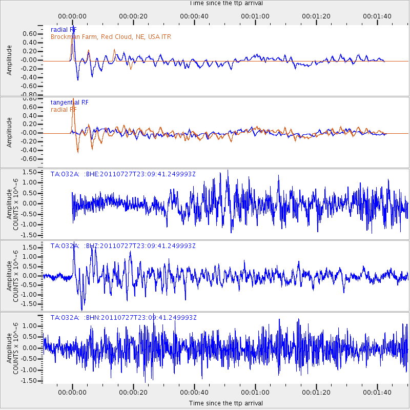
Signal To Noise
| Channel | StoN | STA | LTA |
| TA:O32A: :BHZ:20110727T23:09:41.249993Z | 9.192788 | 8.005595E-7 | 8.708561E-8 |
| TA:O32A: :BHN:20110727T23:09:41.249993Z | 1.1173043 | 3.4353997E-7 | 3.0747216E-7 |
| TA:O32A: :BHE:20110727T23:09:41.249993Z | 1.777849 | 3.967491E-7 | 2.2316242E-7 |
| Arrivals |
| Ps | 5.5 SECOND |
| PpPs | 15 SECOND |
| PsPs/PpSs | 21 SECOND |


