You are here: Home > Network List > TA - USArray Transportable Network (new EarthScope stations) Stations List
> Station 335A Moody, TX, USA > Earthquake Result Viewer
335A Moody, TX, USA - Earthquake Result Viewer
| Earthquake location: |
Northern Mid-Atlantic Ridge |
| Earthquake latitude/longitude: |
10.8/-43.4 |
| Earthquake time(UTC): |
2011/07/27 (208) 23:00:30 GMT |
| Earthquake Depth: |
10 km |
| Earthquake Magnitude: |
5.6 MB, 5.6 MS, 6.0 MW, 5.9 MW |
| Earthquake Catalog/Contributor: |
WHDF/NEIC |
|
| Network: |
TA USArray Transportable Network (new EarthScope stations) |
| Station: |
335A Moody, TX, USA |
| Lat/Lon: |
31.28 N/97.43 W |
| Elevation: |
217 m |
|
| Distance: |
53.8 deg |
| Az: |
300.859 deg |
| Baz: |
99.897 deg |
| Ray Param: |
0.065839864 |
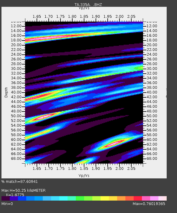
| Estimated Moho Depth: |
50.25 km |
| Estimated Crust Vp/Vs: |
1.68 |
| Assumed Crust Vp: |
6.347 km/s |
| Estimated Crust Vs: |
3.784 km/s |
| Estimated Crust Poisson's Ratio: |
0.22 |
|
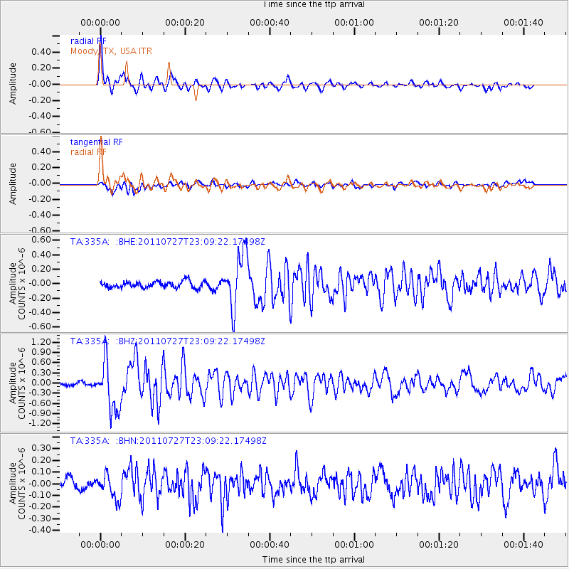
| Radial Match: |
87.60941 % |
| Radial Bump: |
399 |
| Transverse Match: |
71.07413 % |
| Transverse Bump: |
400 |
| SOD ConfigId: |
405110 |
| Insert Time: |
2011-12-29 08:56:17.367 +0000 |
| GWidth: |
2.5 |
| Max Bumps: |
400 |
| Tol: |
0.001 |
|
Signal To Noise
| Channel | StoN | STA | LTA |
| TA:335A: :BHZ:20110727T23:09:22.17498Z | 12.443226 | 7.3887134E-7 | 5.9379403E-8 |
| TA:335A: :BHN:20110727T23:09:22.17498Z | 2.523833 | 1.04545514E-7 | 4.1423306E-8 |
| TA:335A: :BHE:20110727T23:09:22.17498Z | 8.587063 | 3.8353176E-7 | 4.4663906E-8 |
| Arrivals |
| Ps | 5.7 SECOND |
| PpPs | 20 SECOND |
| PsPs/PpSs | 26 SECOND |


