You are here: Home > Network List > TA - USArray Transportable Network (new EarthScope stations) Stations List
> Station S35A Otter Creek Ranch, Eureka, KS, USA > Earthquake Result Viewer
S35A Otter Creek Ranch, Eureka, KS, USA - Earthquake Result Viewer
| Earthquake location: |
Northern Mid-Atlantic Ridge |
| Earthquake latitude/longitude: |
10.8/-43.4 |
| Earthquake time(UTC): |
2011/07/27 (208) 23:00:30 GMT |
| Earthquake Depth: |
10 km |
| Earthquake Magnitude: |
5.6 MB, 5.6 MS, 6.0 MW, 5.9 MW |
| Earthquake Catalog/Contributor: |
WHDF/NEIC |
|
| Network: |
TA USArray Transportable Network (new EarthScope stations) |
| Station: |
S35A Otter Creek Ranch, Eureka, KS, USA |
| Lat/Lon: |
37.68 N/96.32 W |
| Elevation: |
334 m |
|
| Distance: |
54.3 deg |
| Az: |
308.803 deg |
| Baz: |
105.189 deg |
| Ray Param: |
0.065521955 |
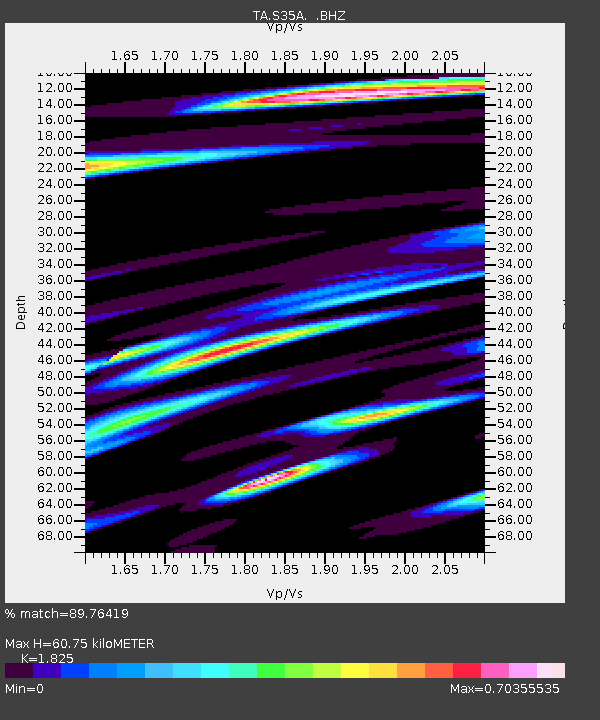
| Estimated Moho Depth: |
60.75 km |
| Estimated Crust Vp/Vs: |
1.83 |
| Assumed Crust Vp: |
6.483 km/s |
| Estimated Crust Vs: |
3.552 km/s |
| Estimated Crust Poisson's Ratio: |
0.29 |
|
| Radial Match: |
89.76419 % |
| Radial Bump: |
400 |
| Transverse Match: |
67.9767 % |
| Transverse Bump: |
400 |
| SOD ConfigId: |
405110 |
| Insert Time: |
2011-12-29 09:00:51.790 +0000 |
| GWidth: |
2.5 |
| Max Bumps: |
400 |
| Tol: |
0.001 |
|
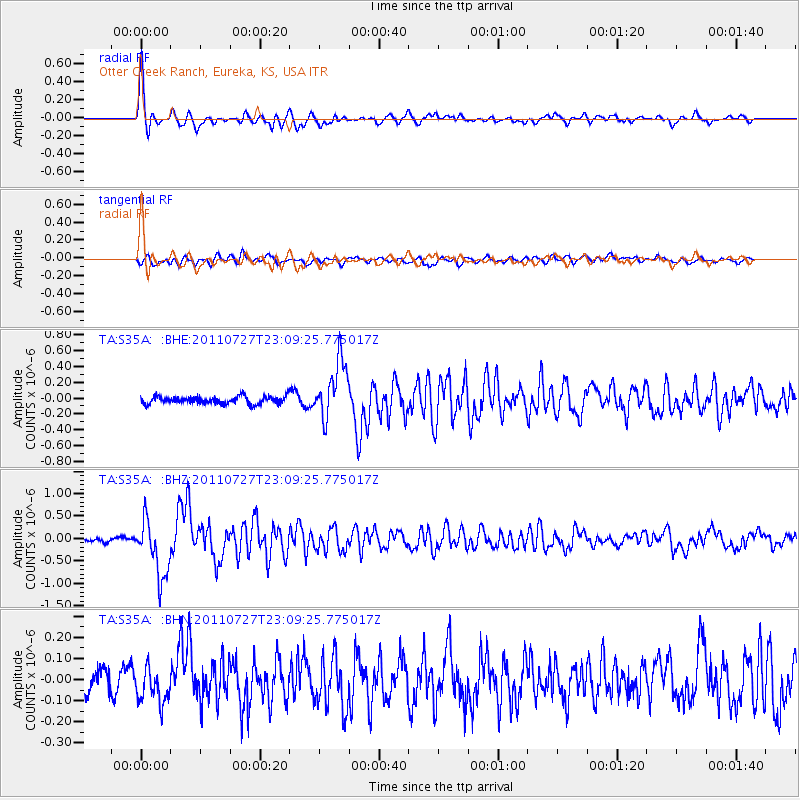
Signal To Noise
| Channel | StoN | STA | LTA |
| TA:S35A: :BHZ:20110727T23:09:25.775017Z | 11.153905 | 6.3322693E-7 | 5.6771768E-8 |
| TA:S35A: :BHN:20110727T23:09:25.775017Z | 1.3818854 | 8.105179E-8 | 5.8653047E-8 |
| TA:S35A: :BHE:20110727T23:09:25.775017Z | 7.6801386 | 3.6146963E-7 | 4.706551E-8 |
| Arrivals |
| Ps | 8.1 SECOND |
| PpPs | 25 SECOND |
| PsPs/PpSs | 33 SECOND |


