You are here: Home > Network List > TA - USArray Transportable Network (new EarthScope stations) Stations List
> Station W36A Wetumka, OK, USA > Earthquake Result Viewer
W36A Wetumka, OK, USA - Earthquake Result Viewer
| Earthquake location: |
Northern Mid-Atlantic Ridge |
| Earthquake latitude/longitude: |
10.8/-43.4 |
| Earthquake time(UTC): |
2011/07/27 (208) 23:00:30 GMT |
| Earthquake Depth: |
10 km |
| Earthquake Magnitude: |
5.6 MB, 5.6 MS, 6.0 MW, 5.9 MW |
| Earthquake Catalog/Contributor: |
WHDF/NEIC |
|
| Network: |
TA USArray Transportable Network (new EarthScope stations) |
| Station: |
W36A Wetumka, OK, USA |
| Lat/Lon: |
35.14 N/96.23 W |
| Elevation: |
251 m |
|
| Distance: |
53.6 deg |
| Az: |
305.785 deg |
| Baz: |
103.468 deg |
| Ray Param: |
0.06597874 |
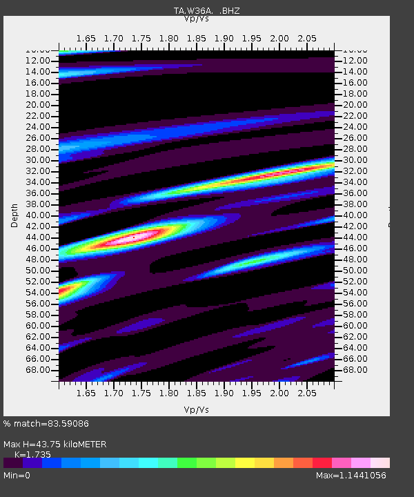
| Estimated Moho Depth: |
43.75 km |
| Estimated Crust Vp/Vs: |
1.74 |
| Assumed Crust Vp: |
6.426 km/s |
| Estimated Crust Vs: |
3.704 km/s |
| Estimated Crust Poisson's Ratio: |
0.25 |
|
| Radial Match: |
83.59086 % |
| Radial Bump: |
400 |
| Transverse Match: |
79.37289 % |
| Transverse Bump: |
391 |
| SOD ConfigId: |
405110 |
| Insert Time: |
2011-12-29 09:01:44.993 +0000 |
| GWidth: |
2.5 |
| Max Bumps: |
400 |
| Tol: |
0.001 |
|
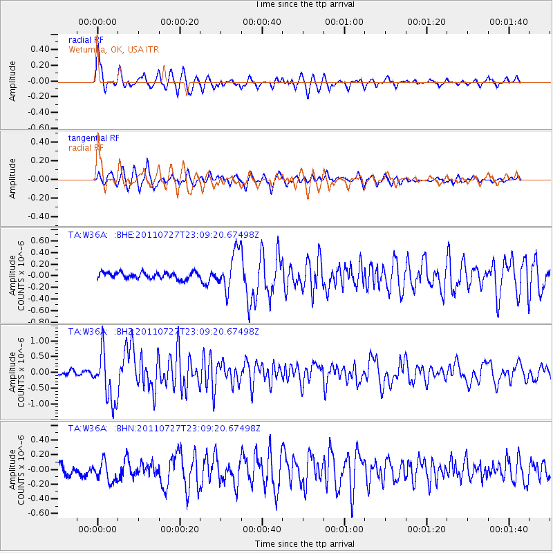
Signal To Noise
| Channel | StoN | STA | LTA |
| TA:W36A: :BHZ:20110727T23:09:20.67498Z | 10.562543 | 8.142563E-7 | 7.7089034E-8 |
| TA:W36A: :BHN:20110727T23:09:20.67498Z | 1.6826376 | 1.5432667E-7 | 9.171712E-8 |
| TA:W36A: :BHE:20110727T23:09:20.67498Z | 6.3330803 | 3.4392212E-7 | 5.4305662E-8 |
| Arrivals |
| Ps | 5.3 SECOND |
| PpPs | 18 SECOND |
| PsPs/PpSs | 23 SECOND |


