You are here: Home > Network List > TA - USArray Transportable Network (new EarthScope stations) Stations List
> Station W35A Tecumseh, OK, USA > Earthquake Result Viewer
W35A Tecumseh, OK, USA - Earthquake Result Viewer
| Earthquake location: |
Northern Mid-Atlantic Ridge |
| Earthquake latitude/longitude: |
10.8/-43.4 |
| Earthquake time(UTC): |
2011/07/27 (208) 23:00:30 GMT |
| Earthquake Depth: |
10 km |
| Earthquake Magnitude: |
5.6 MB, 5.6 MS, 6.0 MW, 5.9 MW |
| Earthquake Catalog/Contributor: |
WHDF/NEIC |
|
| Network: |
TA USArray Transportable Network (new EarthScope stations) |
| Station: |
W35A Tecumseh, OK, USA |
| Lat/Lon: |
35.15 N/96.87 W |
| Elevation: |
322 m |
|
| Distance: |
54.1 deg |
| Az: |
305.651 deg |
| Baz: |
103.018 deg |
| Ray Param: |
0.065634675 |
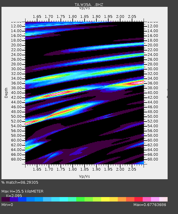
| Estimated Moho Depth: |
35.5 km |
| Estimated Crust Vp/Vs: |
2.10 |
| Assumed Crust Vp: |
6.426 km/s |
| Estimated Crust Vs: |
3.067 km/s |
| Estimated Crust Poisson's Ratio: |
0.35 |
|
| Radial Match: |
86.29305 % |
| Radial Bump: |
400 |
| Transverse Match: |
85.70966 % |
| Transverse Bump: |
400 |
| SOD ConfigId: |
405110 |
| Insert Time: |
2011-12-29 09:01:46.815 +0000 |
| GWidth: |
2.5 |
| Max Bumps: |
400 |
| Tol: |
0.001 |
|

Signal To Noise
| Channel | StoN | STA | LTA |
| TA:W35A: :BHZ:20110727T23:09:24.450005Z | 10.625416 | 9.198491E-7 | 8.6570644E-8 |
| TA:W35A: :BHN:20110727T23:09:24.450005Z | 3.1929207 | 2.544112E-7 | 7.967977E-8 |
| TA:W35A: :BHE:20110727T23:09:24.450005Z | 4.3844943 | 4.6842993E-7 | 1.0683785E-7 |
| Arrivals |
| Ps | 6.3 SECOND |
| PpPs | 16 SECOND |
| PsPs/PpSs | 23 SECOND |


