You are here: Home > Network List > TA - USArray Transportable Network (new EarthScope stations) Stations List
> Station X37A Clayton, OK, USA > Earthquake Result Viewer
X37A Clayton, OK, USA - Earthquake Result Viewer
| Earthquake location: |
Northern Mid-Atlantic Ridge |
| Earthquake latitude/longitude: |
10.8/-43.4 |
| Earthquake time(UTC): |
2011/07/27 (208) 23:00:30 GMT |
| Earthquake Depth: |
10 km |
| Earthquake Magnitude: |
5.6 MB, 5.6 MS, 6.0 MW, 5.9 MW |
| Earthquake Catalog/Contributor: |
WHDF/NEIC |
|
| Network: |
TA USArray Transportable Network (new EarthScope stations) |
| Station: |
X37A Clayton, OK, USA |
| Lat/Lon: |
34.59 N/95.37 W |
| Elevation: |
207 m |
|
| Distance: |
52.8 deg |
| Az: |
305.325 deg |
| Baz: |
103.679 deg |
| Ray Param: |
0.06652344 |
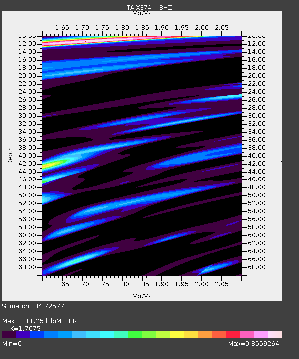
| Estimated Moho Depth: |
11.25 km |
| Estimated Crust Vp/Vs: |
1.71 |
| Assumed Crust Vp: |
6.498 km/s |
| Estimated Crust Vs: |
3.805 km/s |
| Estimated Crust Poisson's Ratio: |
0.24 |
|
| Radial Match: |
84.72577 % |
| Radial Bump: |
400 |
| Transverse Match: |
72.22856 % |
| Transverse Bump: |
400 |
| SOD ConfigId: |
405110 |
| Insert Time: |
2011-12-29 09:02:24.106 +0000 |
| GWidth: |
2.5 |
| Max Bumps: |
400 |
| Tol: |
0.001 |
|

Signal To Noise
| Channel | StoN | STA | LTA |
| TA:X37A: :BHZ:20110727T23:09:14.67498Z | 9.212996 | 7.856182E-7 | 8.527284E-8 |
| TA:X37A: :BHN:20110727T23:09:14.67498Z | 1.0970364 | 7.379598E-8 | 6.726849E-8 |
| TA:X37A: :BHE:20110727T23:09:14.67498Z | 4.26172 | 2.205765E-7 | 5.175762E-8 |
| Arrivals |
| Ps | 1.3 SECOND |
| PpPs | 4.4 SECOND |
| PsPs/PpSs | 5.7 SECOND |


