You are here: Home > Network List > TA - USArray Transportable Network (new EarthScope stations) Stations List
> Station V36A Jenks, OK, USA > Earthquake Result Viewer
V36A Jenks, OK, USA - Earthquake Result Viewer

| Earthquake location: |
Northern Mid-Atlantic Ridge |
| Earthquake latitude/longitude: |
10.8/-43.4 |
| Earthquake time(UTC): |
2011/07/27 (208) 23:00:30 GMT |
| Earthquake Depth: |
10 km |
| Earthquake Magnitude: |
5.6 MB, 5.6 MS, 6.0 MW, 5.9 MW |
| Earthquake Catalog/Contributor: |
WHDF/NEIC |
|
| Network: |
TA USArray Transportable Network (new EarthScope stations) |
| Station: |
V36A Jenks, OK, USA |
| Lat/Lon: |
35.79 N/95.94 W |
| Elevation: |
236 m |
|
| Distance: |
53.5 deg |
| Az: |
306.633 deg |
| Baz: |
104.136 deg |
| Ray Param: |
0.06602639 |
| Estimated Moho Depth: |
25.0 km |
| Estimated Crust Vp/Vs: |
2.09 |
| Assumed Crust Vp: |
6.498 km/s |
| Estimated Crust Vs: |
3.105 km/s |
| Estimated Crust Poisson's Ratio: |
0.35 |
|
| Radial Match: |
89.04314 % |
| Radial Bump: |
400 |
| Transverse Match: |
76.67002 % |
| Transverse Bump: |
400 |
| SOD ConfigId: |
405110 |
| Insert Time: |
2011-12-29 09:05:55.031 +0000 |
| GWidth: |
2.5 |
| Max Bumps: |
400 |
| Tol: |
0.001 |
|
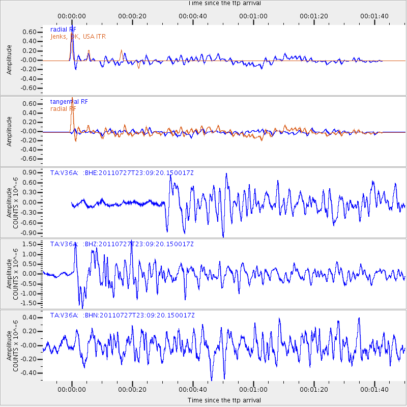
Signal To Noise
| Channel | StoN | STA | LTA |
| TA:V36A: :BHZ:20110727T23:09:20.150017Z | 12.0913 | 9.1909556E-7 | 7.601297E-8 |
| TA:V36A: :BHN:20110727T23:09:20.150017Z | 2.9106104 | 1.5005274E-7 | 5.15537E-8 |
| TA:V36A: :BHE:20110727T23:09:20.150017Z | 8.484642 | 4.609868E-7 | 5.4331906E-8 |
| Arrivals |
| Ps | 4.4 SECOND |
| PpPs | 11 SECOND |
| PsPs/PpSs | 16 SECOND |


