You are here: Home > Network List > TA - USArray Transportable Network (new EarthScope stations) Stations List
> Station O34A Beatrice, NE, USA > Earthquake Result Viewer
O34A Beatrice, NE, USA - Earthquake Result Viewer

| Earthquake location: |
Northern Mid-Atlantic Ridge |
| Earthquake latitude/longitude: |
10.8/-43.4 |
| Earthquake time(UTC): |
2011/07/27 (208) 23:00:30 GMT |
| Earthquake Depth: |
10 km |
| Earthquake Magnitude: |
5.6 MB, 5.6 MS, 6.0 MW, 5.9 MW |
| Earthquake Catalog/Contributor: |
WHDF/NEIC |
|
| Network: |
TA USArray Transportable Network (new EarthScope stations) |
| Station: |
O34A Beatrice, NE, USA |
| Lat/Lon: |
40.18 N/96.69 W |
| Elevation: |
409 m |
|
| Distance: |
55.3 deg |
| Az: |
311.644 deg |
| Baz: |
106.593 deg |
| Ray Param: |
0.06489388 |
| Estimated Moho Depth: |
15.25 km |
| Estimated Crust Vp/Vs: |
1.74 |
| Assumed Crust Vp: |
6.498 km/s |
| Estimated Crust Vs: |
3.745 km/s |
| Estimated Crust Poisson's Ratio: |
0.25 |
|
| Radial Match: |
86.290375 % |
| Radial Bump: |
400 |
| Transverse Match: |
72.54208 % |
| Transverse Bump: |
400 |
| SOD ConfigId: |
405110 |
| Insert Time: |
2011-12-29 09:06:06.630 +0000 |
| GWidth: |
2.5 |
| Max Bumps: |
400 |
| Tol: |
0.001 |
|
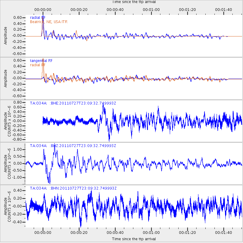
Signal To Noise
| Channel | StoN | STA | LTA |
| TA:O34A: :BHZ:20110727T23:09:32.749993Z | 10.122289 | 6.964903E-7 | 6.8807594E-8 |
| TA:O34A: :BHN:20110727T23:09:32.749993Z | 1.5783262 | 1.5266642E-7 | 9.672677E-8 |
| TA:O34A: :BHE:20110727T23:09:32.749993Z | 3.9884174 | 3.239972E-7 | 8.1234525E-8 |
| Arrivals |
| Ps | 1.8 SECOND |
| PpPs | 6.1 SECOND |
| PsPs/PpSs | 7.9 SECOND |


