You are here: Home > Network List > TA - USArray Transportable Network (new EarthScope stations) Stations List
> Station H32A Carlson Farm, Erwin, SD, USA > Earthquake Result Viewer
H32A Carlson Farm, Erwin, SD, USA - Earthquake Result Viewer

| Earthquake location: |
Northern Mid-Atlantic Ridge |
| Earthquake latitude/longitude: |
10.8/-43.4 |
| Earthquake time(UTC): |
2011/07/27 (208) 23:00:30 GMT |
| Earthquake Depth: |
10 km |
| Earthquake Magnitude: |
5.6 MB, 5.6 MS, 6.0 MW, 5.9 MW |
| Earthquake Catalog/Contributor: |
WHDF/NEIC |
|
| Network: |
TA USArray Transportable Network (new EarthScope stations) |
| Station: |
H32A Carlson Farm, Erwin, SD, USA |
| Lat/Lon: |
44.50 N/97.44 W |
| Elevation: |
573 m |
|
| Distance: |
57.1 deg |
| Az: |
316.395 deg |
| Baz: |
108.738 deg |
| Ray Param: |
0.063693956 |
| Estimated Moho Depth: |
10.5 km |
| Estimated Crust Vp/Vs: |
1.62 |
| Assumed Crust Vp: |
6.552 km/s |
| Estimated Crust Vs: |
4.057 km/s |
| Estimated Crust Poisson's Ratio: |
0.19 |
|
| Radial Match: |
92.30232 % |
| Radial Bump: |
384 |
| Transverse Match: |
63.381947 % |
| Transverse Bump: |
400 |
| SOD ConfigId: |
405110 |
| Insert Time: |
2011-12-29 09:08:45.847 +0000 |
| GWidth: |
2.5 |
| Max Bumps: |
400 |
| Tol: |
0.001 |
|
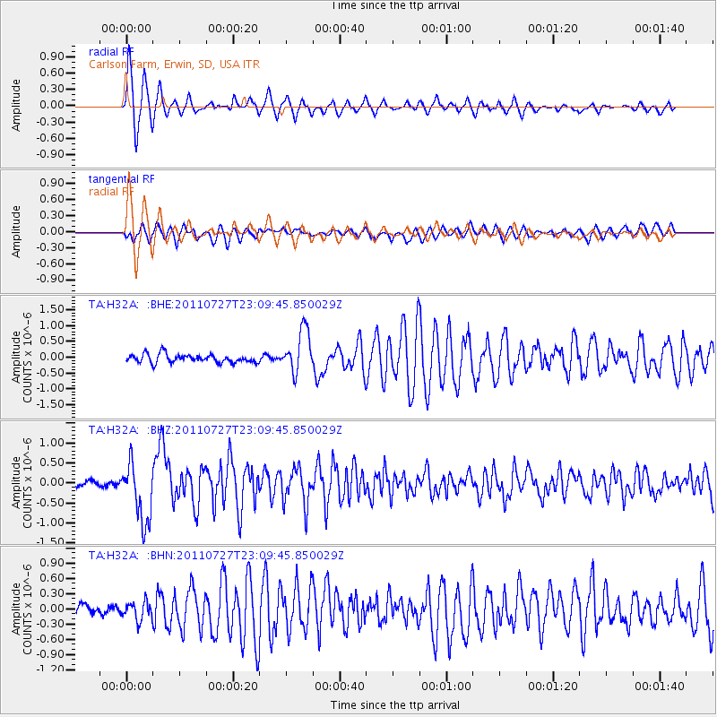
Signal To Noise
| Channel | StoN | STA | LTA |
| TA:H32A: :BHZ:20110727T23:09:45.850029Z | 8.617591 | 7.499834E-7 | 8.702936E-8 |
| TA:H32A: :BHN:20110727T23:09:45.850029Z | 0.77829415 | 1.7896534E-7 | 2.2994563E-7 |
| TA:H32A: :BHE:20110727T23:09:45.850029Z | 5.0897927 | 6.775632E-7 | 1.3312196E-7 |
| Arrivals |
| Ps | 1.0 SECOND |
| PpPs | 4.0 SECOND |
| PsPs/PpSs | 5.0 SECOND |


