You are here: Home > Network List > TA - USArray Transportable Network (new EarthScope stations) Stations List
> Station D32A Dogwood Acres, Gardner, ND, USA > Earthquake Result Viewer
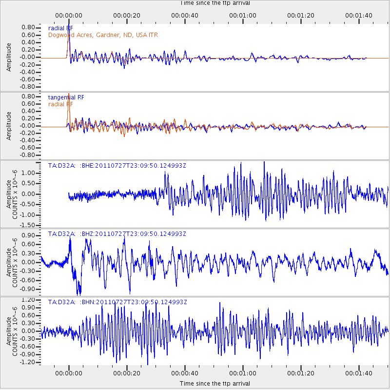
D32A Dogwood Acres, Gardner, ND, USA - Earthquake Result Viewer
*The percent match for this event was below the threshold and hence no stack was calculated.
| Earthquake location: |
Northern Mid-Atlantic Ridge |
| Earthquake latitude/longitude: |
10.8/-43.4 |
| Earthquake time(UTC): |
2011/07/27 (208) 23:00:30 GMT |
| Earthquake Depth: |
10 km |
| Earthquake Magnitude: |
5.6 MB, 5.6 MS, 6.0 MW, 5.9 MW |
| Earthquake Catalog/Contributor: |
WHDF/NEIC |
|
| Network: |
TA USArray Transportable Network (new EarthScope stations) |
| Station: |
D32A Dogwood Acres, Gardner, ND, USA |
| Lat/Lon: |
47.14 N/97.02 W |
| Elevation: |
280 m |
|
| Distance: |
57.7 deg |
| Az: |
319.452 deg |
| Baz: |
110.684 deg |
| Ray Param: |
$rayparam |
*The percent match for this event was below the threshold and hence was not used in the summary stack. |
|
| Radial Match: |
74.212746 % |
| Radial Bump: |
400 |
| Transverse Match: |
58.649643 % |
| Transverse Bump: |
400 |
| SOD ConfigId: |
405110 |
| Insert Time: |
2011-12-29 09:09:51.063 +0000 |
| GWidth: |
2.5 |
| Max Bumps: |
400 |
| Tol: |
0.001 |
|
Signal To Noise
| Channel | StoN | STA | LTA |
| TA:D32A: :BHZ:20110727T23:09:50.124993Z | 7.209766 | 5.558284E-7 | 7.709382E-8 |
| TA:D32A: :BHN:20110727T23:09:50.124993Z | 2.1769428 | 2.0407822E-7 | 9.374533E-8 |
| TA:D32A: :BHE:20110727T23:09:50.124993Z | 3.6177156 | 4.121537E-7 | 1.13926504E-7 |
| Arrivals |
| Ps | |
| PpPs | |
| PsPs/PpSs | |


