You are here: Home > Network List > TA - USArray Transportable Network (new EarthScope stations) Stations List
> Station F31A Hecla, SD, USA > Earthquake Result Viewer
F31A Hecla, SD, USA - Earthquake Result Viewer
| Earthquake location: |
Northern Mid-Atlantic Ridge |
| Earthquake latitude/longitude: |
10.8/-43.4 |
| Earthquake time(UTC): |
2011/07/27 (208) 23:00:30 GMT |
| Earthquake Depth: |
10 km |
| Earthquake Magnitude: |
5.6 MB, 5.6 MS, 6.0 MW, 5.9 MW |
| Earthquake Catalog/Contributor: |
WHDF/NEIC |
|
| Network: |
TA USArray Transportable Network (new EarthScope stations) |
| Station: |
F31A Hecla, SD, USA |
| Lat/Lon: |
45.86 N/98.25 W |
| Elevation: |
412 m |
|
| Distance: |
58.1 deg |
| Az: |
317.694 deg |
| Baz: |
108.857 deg |
| Ray Param: |
0.06306206 |
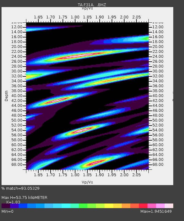
| Estimated Moho Depth: |
53.75 km |
| Estimated Crust Vp/Vs: |
1.83 |
| Assumed Crust Vp: |
6.53 km/s |
| Estimated Crust Vs: |
3.569 km/s |
| Estimated Crust Poisson's Ratio: |
0.29 |
|
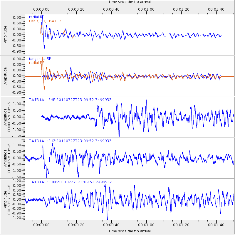
| Radial Match: |
93.05329 % |
| Radial Bump: |
400 |
| Transverse Match: |
86.81122 % |
| Transverse Bump: |
400 |
| SOD ConfigId: |
405110 |
| Insert Time: |
2011-12-29 09:12:23.562 +0000 |
| GWidth: |
2.5 |
| Max Bumps: |
400 |
| Tol: |
0.001 |
|
Signal To Noise
| Channel | StoN | STA | LTA |
| TA:F31A: :BHZ:20110727T23:09:52.749993Z | 9.434152 | 7.0384897E-7 | 7.460649E-8 |
| TA:F31A: :BHN:20110727T23:09:52.749993Z | 2.3166375 | 1.856487E-7 | 8.0137134E-8 |
| TA:F31A: :BHE:20110727T23:09:52.749993Z | 5.316753 | 4.82796E-7 | 9.0806545E-8 |
| Arrivals |
| Ps | 7.2 SECOND |
| PpPs | 22 SECOND |
| PsPs/PpSs | 29 SECOND |


