You are here: Home > Network List > TA - USArray Transportable Network (new EarthScope stations) Stations List
> Station C39A Grand Marais, MN, USA > Earthquake Result Viewer
C39A Grand Marais, MN, USA - Earthquake Result Viewer

| Earthquake location: |
Northern Mid-Atlantic Ridge |
| Earthquake latitude/longitude: |
10.8/-43.4 |
| Earthquake time(UTC): |
2011/07/27 (208) 23:00:30 GMT |
| Earthquake Depth: |
10 km |
| Earthquake Magnitude: |
5.6 MB, 5.6 MS, 6.0 MW, 5.9 MW |
| Earthquake Catalog/Contributor: |
WHDF/NEIC |
|
| Network: |
TA USArray Transportable Network (new EarthScope stations) |
| Station: |
C39A Grand Marais, MN, USA |
| Lat/Lon: |
47.82 N/90.13 W |
| Elevation: |
341 m |
|
| Distance: |
53.7 deg |
| Az: |
322.51 deg |
| Baz: |
117.47 deg |
| Ray Param: |
0.06589443 |
| Estimated Moho Depth: |
35.25 km |
| Estimated Crust Vp/Vs: |
1.80 |
| Assumed Crust Vp: |
6.467 km/s |
| Estimated Crust Vs: |
3.598 km/s |
| Estimated Crust Poisson's Ratio: |
0.28 |
|
| Radial Match: |
84.55288 % |
| Radial Bump: |
400 |
| Transverse Match: |
73.19851 % |
| Transverse Bump: |
400 |
| SOD ConfigId: |
405110 |
| Insert Time: |
2011-12-29 09:13:38.289 +0000 |
| GWidth: |
2.5 |
| Max Bumps: |
400 |
| Tol: |
0.001 |
|
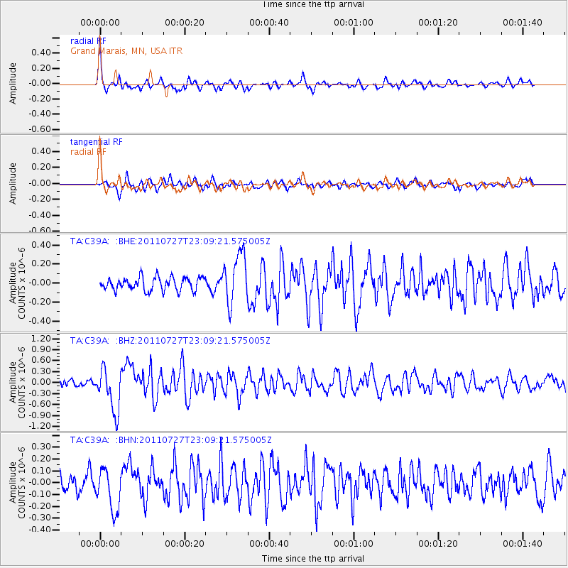
Signal To Noise
| Channel | StoN | STA | LTA |
| TA:C39A: :BHZ:20110727T23:09:21.575005Z | 7.791892 | 6.0241064E-7 | 7.731249E-8 |
| TA:C39A: :BHN:20110727T23:09:21.575005Z | 3.0817103 | 1.8327216E-7 | 5.947092E-8 |
| TA:C39A: :BHE:20110727T23:09:21.575005Z | 3.943103 | 2.6774606E-7 | 6.790238E-8 |
| Arrivals |
| Ps | 4.6 SECOND |
| PpPs | 14 SECOND |
| PsPs/PpSs | 19 SECOND |


