You are here: Home > Network List > TA - USArray Transportable Network (new EarthScope stations) Stations List
> Station H37A Dierke Farm, Cannon Falls, MN, USA > Earthquake Result Viewer
H37A Dierke Farm, Cannon Falls, MN, USA - Earthquake Result Viewer
| Earthquake location: |
Northern Mid-Atlantic Ridge |
| Earthquake latitude/longitude: |
10.8/-43.4 |
| Earthquake time(UTC): |
2011/07/27 (208) 23:00:30 GMT |
| Earthquake Depth: |
10 km |
| Earthquake Magnitude: |
5.6 MB, 5.6 MS, 6.0 MW, 5.9 MW |
| Earthquake Catalog/Contributor: |
WHDF/NEIC |
|
| Network: |
TA USArray Transportable Network (new EarthScope stations) |
| Station: |
H37A Dierke Farm, Cannon Falls, MN, USA |
| Lat/Lon: |
44.58 N/92.92 W |
| Elevation: |
321 m |
|
| Distance: |
54.1 deg |
| Az: |
317.868 deg |
| Baz: |
112.729 deg |
| Ray Param: |
0.06564231 |
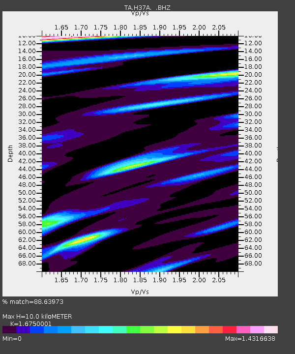
| Estimated Moho Depth: |
10.0 km |
| Estimated Crust Vp/Vs: |
1.68 |
| Assumed Crust Vp: |
6.571 km/s |
| Estimated Crust Vs: |
3.923 km/s |
| Estimated Crust Poisson's Ratio: |
0.22 |
|
| Radial Match: |
88.63973 % |
| Radial Bump: |
400 |
| Transverse Match: |
74.96547 % |
| Transverse Bump: |
400 |
| SOD ConfigId: |
405110 |
| Insert Time: |
2011-12-29 09:13:54.956 +0000 |
| GWidth: |
2.5 |
| Max Bumps: |
400 |
| Tol: |
0.001 |
|

Signal To Noise
| Channel | StoN | STA | LTA |
| TA:H37A: :BHZ:20110727T23:09:24.350029Z | 6.4170966 | 8.7336736E-7 | 1.3610008E-7 |
| TA:H37A: :BHN:20110727T23:09:24.350029Z | 1.5790536 | 2.5929282E-7 | 1.6420773E-7 |
| TA:H37A: :BHE:20110727T23:09:24.350029Z | 2.0710928 | 3.7583845E-7 | 1.8146868E-7 |
| Arrivals |
| Ps | 1.1 SECOND |
| PpPs | 3.8 SECOND |
| PsPs/PpSs | 4.9 SECOND |


