You are here: Home > Network List > TA - USArray Transportable Network (new EarthScope stations) Stations List
> Station I38A Scanlan Farm, Eyota, MN, USA > Earthquake Result Viewer
I38A Scanlan Farm, Eyota, MN, USA - Earthquake Result Viewer
| Earthquake location: |
Northern Mid-Atlantic Ridge |
| Earthquake latitude/longitude: |
10.8/-43.4 |
| Earthquake time(UTC): |
2011/07/27 (208) 23:00:30 GMT |
| Earthquake Depth: |
10 km |
| Earthquake Magnitude: |
5.6 MB, 5.6 MS, 6.0 MW, 5.9 MW |
| Earthquake Catalog/Contributor: |
WHDF/NEIC |
|
| Network: |
TA USArray Transportable Network (new EarthScope stations) |
| Station: |
I38A Scanlan Farm, Eyota, MN, USA |
| Lat/Lon: |
44.04 N/92.33 W |
| Elevation: |
390 m |
|
| Distance: |
53.5 deg |
| Az: |
317.453 deg |
| Baz: |
112.893 deg |
| Ray Param: |
0.06603946 |
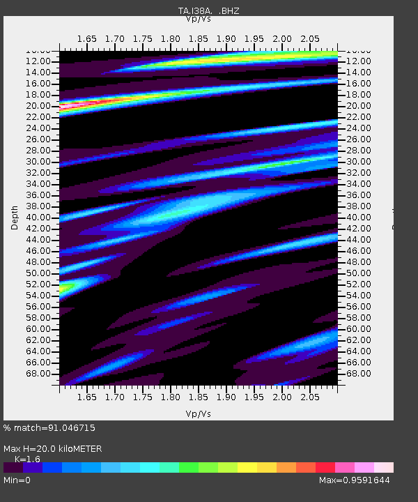
| Estimated Moho Depth: |
20.0 km |
| Estimated Crust Vp/Vs: |
1.60 |
| Assumed Crust Vp: |
6.571 km/s |
| Estimated Crust Vs: |
4.107 km/s |
| Estimated Crust Poisson's Ratio: |
0.18 |
|
| Radial Match: |
91.046715 % |
| Radial Bump: |
344 |
| Transverse Match: |
75.37208 % |
| Transverse Bump: |
400 |
| SOD ConfigId: |
405110 |
| Insert Time: |
2011-12-29 09:14:24.114 +0000 |
| GWidth: |
2.5 |
| Max Bumps: |
400 |
| Tol: |
0.001 |
|

Signal To Noise
| Channel | StoN | STA | LTA |
| TA:I38A: :BHZ:20110727T23:09:19.999993Z | 11.73549 | 7.50991E-7 | 6.399315E-8 |
| TA:I38A: :BHN:20110727T23:09:19.999993Z | 2.6411827 | 2.3093784E-7 | 8.7437286E-8 |
| TA:I38A: :BHE:20110727T23:09:19.999993Z | 6.5006943 | 3.5512434E-7 | 5.462868E-8 |
| Arrivals |
| Ps | 1.9 SECOND |
| PpPs | 7.4 SECOND |
| PsPs/PpSs | 9.4 SECOND |


