You are here: Home > Network List > TA - USArray Transportable Network (new EarthScope stations) Stations List
> Station A32A Rocking H Ranch, Lancaster, MN, USA > Earthquake Result Viewer
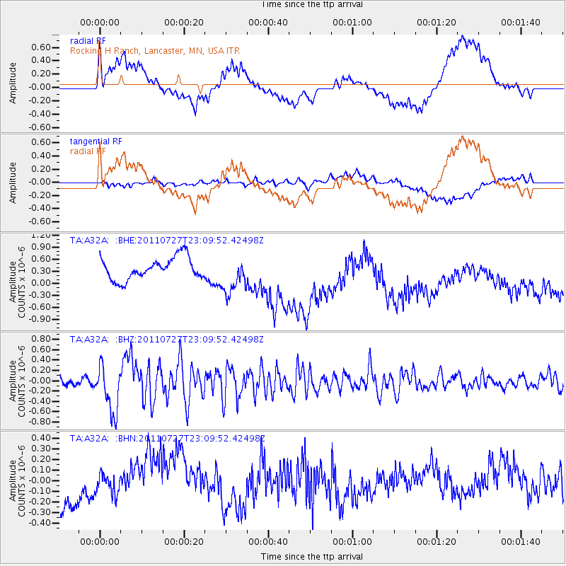
A32A Rocking H Ranch, Lancaster, MN, USA - Earthquake Result Viewer
*The percent match for this event was below the threshold and hence no stack was calculated.
| Earthquake location: |
Northern Mid-Atlantic Ridge |
| Earthquake latitude/longitude: |
10.8/-43.4 |
| Earthquake time(UTC): |
2011/07/27 (208) 23:00:30 GMT |
| Earthquake Depth: |
10 km |
| Earthquake Magnitude: |
5.6 MB, 5.6 MS, 6.0 MW, 5.9 MW |
| Earthquake Catalog/Contributor: |
WHDF/NEIC |
|
| Network: |
TA USArray Transportable Network (new EarthScope stations) |
| Station: |
A32A Rocking H Ranch, Lancaster, MN, USA |
| Lat/Lon: |
48.92 N/96.49 W |
| Elevation: |
322 m |
|
| Distance: |
58.1 deg |
| Az: |
321.563 deg |
| Baz: |
112.194 deg |
| Ray Param: |
$rayparam |
*The percent match for this event was below the threshold and hence was not used in the summary stack. |
|
| Radial Match: |
29.976479 % |
| Radial Bump: |
400 |
| Transverse Match: |
20.051859 % |
| Transverse Bump: |
400 |
| SOD ConfigId: |
405110 |
| Insert Time: |
2011-12-29 09:15:27.882 +0000 |
| GWidth: |
2.5 |
| Max Bumps: |
400 |
| Tol: |
0.001 |
|
Signal To Noise
| Channel | StoN | STA | LTA |
| TA:A32A: :BHZ:20110727T23:09:52.42498Z | 7.5624714 | 4.6947778E-7 | 6.207994E-8 |
| TA:A32A: :BHN:20110727T23:09:52.42498Z | 0.3257848 | 1.10135545E-7 | 3.3806228E-7 |
| TA:A32A: :BHE:20110727T23:09:52.42498Z | 1.7484174 | 4.7397202E-7 | 2.7108632E-7 |
| Arrivals |
| Ps | |
| PpPs | |
| PsPs/PpSs | |


