You are here: Home > Network List > TA - USArray Transportable Network (new EarthScope stations) Stations List
> Station N39A Derby Farms, Drakesville, IA, USA > Earthquake Result Viewer
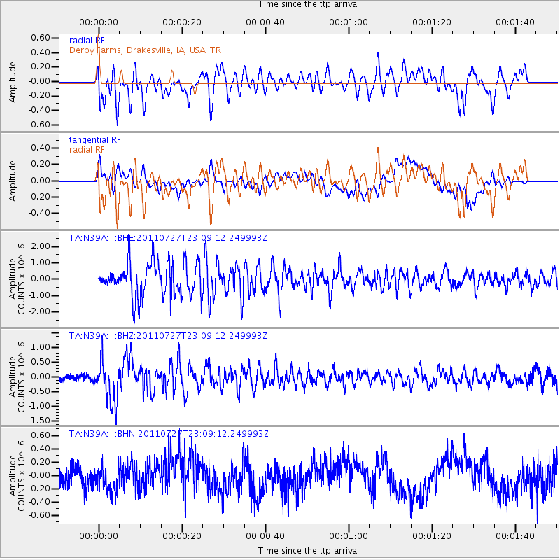
N39A Derby Farms, Drakesville, IA, USA - Earthquake Result Viewer
*The percent match for this event was below the threshold and hence no stack was calculated.
| Earthquake location: |
Northern Mid-Atlantic Ridge |
| Earthquake latitude/longitude: |
10.8/-43.4 |
| Earthquake time(UTC): |
2011/07/27 (208) 23:00:30 GMT |
| Earthquake Depth: |
10 km |
| Earthquake Magnitude: |
5.6 MB, 5.6 MS, 6.0 MW, 5.9 MW |
| Earthquake Catalog/Contributor: |
WHDF/NEIC |
|
| Network: |
TA USArray Transportable Network (new EarthScope stations) |
| Station: |
N39A Derby Farms, Drakesville, IA, USA |
| Lat/Lon: |
40.88 N/92.50 W |
| Elevation: |
260 m |
|
| Distance: |
52.5 deg |
| Az: |
313.717 deg |
| Baz: |
110.528 deg |
| Ray Param: |
$rayparam |
*The percent match for this event was below the threshold and hence was not used in the summary stack. |
|
| Radial Match: |
37.711693 % |
| Radial Bump: |
400 |
| Transverse Match: |
47.342625 % |
| Transverse Bump: |
400 |
| SOD ConfigId: |
405110 |
| Insert Time: |
2011-12-29 09:16:47.168 +0000 |
| GWidth: |
2.5 |
| Max Bumps: |
400 |
| Tol: |
0.001 |
|
Signal To Noise
| Channel | StoN | STA | LTA |
| TA:N39A: :BHZ:20110727T23:09:12.249993Z | 10.562905 | 7.1402667E-7 | 6.759756E-8 |
| TA:N39A: :BHN:20110727T23:09:12.249993Z | 1.5414326 | 1.798624E-7 | 1.16685214E-7 |
| TA:N39A: :BHE:20110727T23:09:12.249993Z | 0.8382631 | 8.4602505E-7 | 1.0092596E-6 |
| Arrivals |
| Ps | |
| PpPs | |
| PsPs/PpSs | |


