You are here: Home > Network List > TA - USArray Transportable Network (new EarthScope stations) Stations List
> Station Q38A Cook's Store, Concordia, MO, USA > Earthquake Result Viewer
Q38A Cook's Store, Concordia, MO, USA - Earthquake Result Viewer
| Earthquake location: |
Northern Mid-Atlantic Ridge |
| Earthquake latitude/longitude: |
10.8/-43.4 |
| Earthquake time(UTC): |
2011/07/27 (208) 23:00:30 GMT |
| Earthquake Depth: |
10 km |
| Earthquake Magnitude: |
5.6 MB, 5.6 MS, 6.0 MW, 5.9 MW |
| Earthquake Catalog/Contributor: |
WHDF/NEIC |
|
| Network: |
TA USArray Transportable Network (new EarthScope stations) |
| Station: |
Q38A Cook's Store, Concordia, MO, USA |
| Lat/Lon: |
38.96 N/93.62 W |
| Elevation: |
228 m |
|
| Distance: |
52.7 deg |
| Az: |
311.084 deg |
| Baz: |
108.214 deg |
| Ray Param: |
0.06662297 |
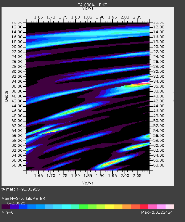
| Estimated Moho Depth: |
34.0 km |
| Estimated Crust Vp/Vs: |
2.09 |
| Assumed Crust Vp: |
6.498 km/s |
| Estimated Crust Vs: |
3.105 km/s |
| Estimated Crust Poisson's Ratio: |
0.35 |
|
| Radial Match: |
91.33955 % |
| Radial Bump: |
400 |
| Transverse Match: |
56.858963 % |
| Transverse Bump: |
400 |
| SOD ConfigId: |
405110 |
| Insert Time: |
2011-12-29 09:17:42.156 +0000 |
| GWidth: |
2.5 |
| Max Bumps: |
400 |
| Tol: |
0.001 |
|

Signal To Noise
| Channel | StoN | STA | LTA |
| TA:Q38A: :BHZ:20110727T23:09:13.54998Z | 20.009478 | 9.304843E-7 | 4.650218E-8 |
| TA:Q38A: :BHN:20110727T23:09:13.54998Z | 1.9976959 | 1.3486759E-7 | 6.7511564E-8 |
| TA:Q38A: :BHE:20110727T23:09:13.54998Z | 9.325755 | 4.3640918E-7 | 4.6796124E-8 |
| Arrivals |
| Ps | 6.0 SECOND |
| PpPs | 15 SECOND |
| PsPs/PpSs | 21 SECOND |


