You are here: Home > Network List > TA - USArray Transportable Network (new EarthScope stations) Stations List
> Station O39A Kirksville, MO, USA > Earthquake Result Viewer
O39A Kirksville, MO, USA - Earthquake Result Viewer
| Earthquake location: |
Northern Mid-Atlantic Ridge |
| Earthquake latitude/longitude: |
10.8/-43.4 |
| Earthquake time(UTC): |
2011/07/27 (208) 23:00:30 GMT |
| Earthquake Depth: |
10 km |
| Earthquake Magnitude: |
5.6 MB, 5.6 MS, 6.0 MW, 5.9 MW |
| Earthquake Catalog/Contributor: |
WHDF/NEIC |
|
| Network: |
TA USArray Transportable Network (new EarthScope stations) |
| Station: |
O39A Kirksville, MO, USA |
| Lat/Lon: |
40.25 N/92.54 W |
| Elevation: |
282 m |
|
| Distance: |
52.3 deg |
| Az: |
312.966 deg |
| Baz: |
110.043 deg |
| Ray Param: |
0.06685386 |
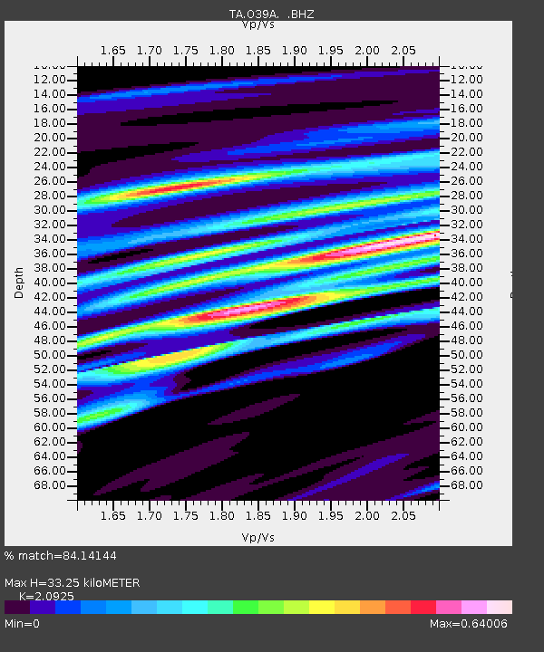
| Estimated Moho Depth: |
33.25 km |
| Estimated Crust Vp/Vs: |
2.09 |
| Assumed Crust Vp: |
6.498 km/s |
| Estimated Crust Vs: |
3.105 km/s |
| Estimated Crust Poisson's Ratio: |
0.35 |
|
| Radial Match: |
84.14144 % |
| Radial Bump: |
400 |
| Transverse Match: |
68.946526 % |
| Transverse Bump: |
400 |
| SOD ConfigId: |
405110 |
| Insert Time: |
2011-12-29 09:17:57.601 +0000 |
| GWidth: |
2.5 |
| Max Bumps: |
400 |
| Tol: |
0.001 |
|

Signal To Noise
| Channel | StoN | STA | LTA |
| TA:O39A: :BHZ:20110727T23:09:10.874993Z | 7.0676 | 6.8911805E-7 | 9.750383E-8 |
| TA:O39A: :BHN:20110727T23:09:10.874993Z | 2.0189729 | 2.2775028E-7 | 1.1280502E-7 |
| TA:O39A: :BHE:20110727T23:09:10.874993Z | 4.760619 | 5.311917E-7 | 1.1158038E-7 |
| Arrivals |
| Ps | 5.9 SECOND |
| PpPs | 15 SECOND |
| PsPs/PpSs | 21 SECOND |


