You are here: Home > Network List > TA - USArray Transportable Network (new EarthScope stations) Stations List
> Station S38A Stockton, MO, USA > Earthquake Result Viewer
S38A Stockton, MO, USA - Earthquake Result Viewer
| Earthquake location: |
Northern Mid-Atlantic Ridge |
| Earthquake latitude/longitude: |
10.8/-43.4 |
| Earthquake time(UTC): |
2011/07/27 (208) 23:00:30 GMT |
| Earthquake Depth: |
10 km |
| Earthquake Magnitude: |
5.6 MB, 5.6 MS, 6.0 MW, 5.9 MW |
| Earthquake Catalog/Contributor: |
WHDF/NEIC |
|
| Network: |
TA USArray Transportable Network (new EarthScope stations) |
| Station: |
S38A Stockton, MO, USA |
| Lat/Lon: |
37.63 N/93.91 W |
| Elevation: |
294 m |
|
| Distance: |
52.5 deg |
| Az: |
309.402 deg |
| Baz: |
107.013 deg |
| Ray Param: |
0.06674119 |
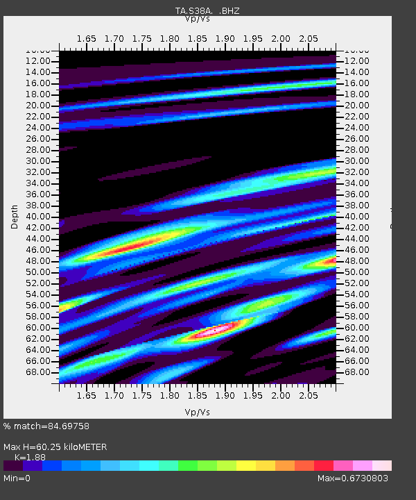
| Estimated Moho Depth: |
60.25 km |
| Estimated Crust Vp/Vs: |
1.88 |
| Assumed Crust Vp: |
6.53 km/s |
| Estimated Crust Vs: |
3.474 km/s |
| Estimated Crust Poisson's Ratio: |
0.30 |
|
| Radial Match: |
84.69758 % |
| Radial Bump: |
400 |
| Transverse Match: |
62.015984 % |
| Transverse Bump: |
400 |
| SOD ConfigId: |
405110 |
| Insert Time: |
2011-12-29 09:18:43.824 +0000 |
| GWidth: |
2.5 |
| Max Bumps: |
400 |
| Tol: |
0.001 |
|

Signal To Noise
| Channel | StoN | STA | LTA |
| TA:S38A: :BHZ:20110727T23:09:12.17498Z | 12.1255045 | 7.6009604E-7 | 6.268573E-8 |
| TA:S38A: :BHN:20110727T23:09:12.17498Z | 1.8390902 | 1.3264736E-7 | 7.212662E-8 |
| TA:S38A: :BHE:20110727T23:09:12.17498Z | 9.637901 | 4.1218993E-7 | 4.2767603E-8 |
| Arrivals |
| Ps | 8.6 SECOND |
| PpPs | 25 SECOND |
| PsPs/PpSs | 34 SECOND |


