You are here: Home > Network List > TA - USArray Transportable Network (new EarthScope stations) Stations List
> Station X40A Basin Creek Farm, Marlvern, AR, USA > Earthquake Result Viewer
X40A Basin Creek Farm, Marlvern, AR, USA - Earthquake Result Viewer
| Earthquake location: |
Northern Mid-Atlantic Ridge |
| Earthquake latitude/longitude: |
10.8/-43.4 |
| Earthquake time(UTC): |
2011/07/27 (208) 23:00:30 GMT |
| Earthquake Depth: |
10 km |
| Earthquake Magnitude: |
5.6 MB, 5.6 MS, 6.0 MW, 5.9 MW |
| Earthquake Catalog/Contributor: |
WHDF/NEIC |
|
| Network: |
TA USArray Transportable Network (new EarthScope stations) |
| Station: |
X40A Basin Creek Farm, Marlvern, AR, USA |
| Lat/Lon: |
34.49 N/92.83 W |
| Elevation: |
158 m |
|
| Distance: |
50.8 deg |
| Az: |
305.87 deg |
| Baz: |
105.449 deg |
| Ray Param: |
0.067843616 |
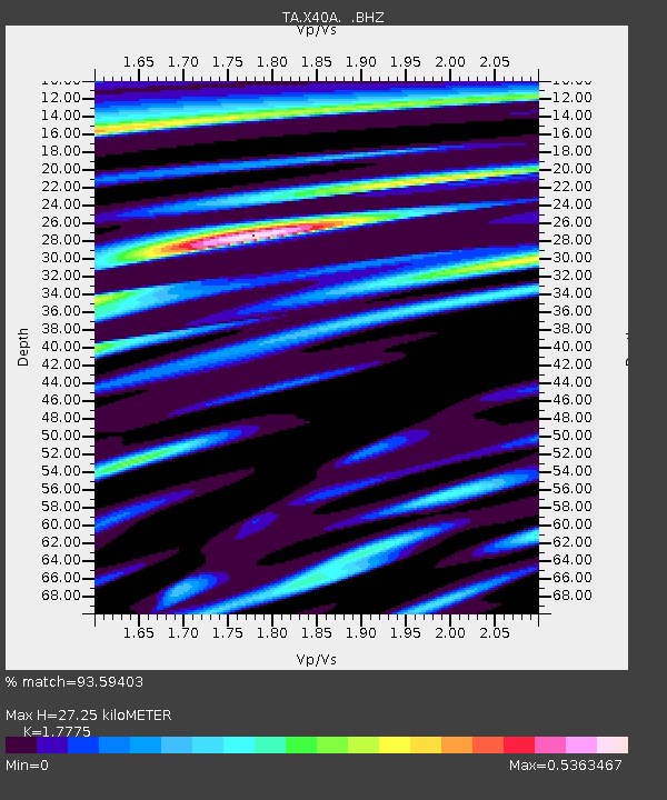
| Estimated Moho Depth: |
27.25 km |
| Estimated Crust Vp/Vs: |
1.78 |
| Assumed Crust Vp: |
6.498 km/s |
| Estimated Crust Vs: |
3.655 km/s |
| Estimated Crust Poisson's Ratio: |
0.27 |
|
| Radial Match: |
93.59403 % |
| Radial Bump: |
400 |
| Transverse Match: |
79.68618 % |
| Transverse Bump: |
400 |
| SOD ConfigId: |
405110 |
| Insert Time: |
2011-12-29 09:19:04.159 +0000 |
| GWidth: |
2.5 |
| Max Bumps: |
400 |
| Tol: |
0.001 |
|

Signal To Noise
| Channel | StoN | STA | LTA |
| TA:X40A: :BHZ:20110727T23:08:59.399987Z | 18.226267 | 7.87801E-7 | 4.322339E-8 |
| TA:X40A: :BHN:20110727T23:08:59.399987Z | 1.6889782 | 6.348868E-8 | 3.758999E-8 |
| TA:X40A: :BHE:20110727T23:08:59.399987Z | 9.984264 | 3.319199E-7 | 3.3244298E-8 |
| Arrivals |
| Ps | 3.5 SECOND |
| PpPs | 11 SECOND |
| PsPs/PpSs | 14 SECOND |


