You are here: Home > Network List > TA - USArray Transportable Network (new EarthScope stations) Stations List
> Station 146A Union, MS, USA > Earthquake Result Viewer
146A Union, MS, USA - Earthquake Result Viewer
| Earthquake location: |
Northern Mid-Atlantic Ridge |
| Earthquake latitude/longitude: |
10.8/-43.4 |
| Earthquake time(UTC): |
2011/07/27 (208) 23:00:30 GMT |
| Earthquake Depth: |
10 km |
| Earthquake Magnitude: |
5.6 MB, 5.6 MS, 6.0 MW, 5.9 MW |
| Earthquake Catalog/Contributor: |
WHDF/NEIC |
|
| Network: |
TA USArray Transportable Network (new EarthScope stations) |
| Station: |
146A Union, MS, USA |
| Lat/Lon: |
32.64 N/89.06 W |
| Elevation: |
164 m |
|
| Distance: |
47.2 deg |
| Az: |
304.68 deg |
| Baz: |
106.746 deg |
| Ray Param: |
0.07014023 |
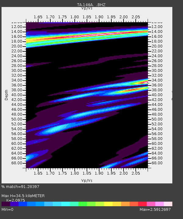
| Estimated Moho Depth: |
34.5 km |
| Estimated Crust Vp/Vs: |
2.10 |
| Assumed Crust Vp: |
6.201 km/s |
| Estimated Crust Vs: |
2.957 km/s |
| Estimated Crust Poisson's Ratio: |
0.35 |
|
| Radial Match: |
91.28397 % |
| Radial Bump: |
400 |
| Transverse Match: |
77.44255 % |
| Transverse Bump: |
400 |
| SOD ConfigId: |
405110 |
| Insert Time: |
2011-12-29 09:22:46.102 +0000 |
| GWidth: |
2.5 |
| Max Bumps: |
400 |
| Tol: |
0.001 |
|

Signal To Noise
| Channel | StoN | STA | LTA |
| TA:146A: :BHZ:20110727T23:08:32.274987Z | 8.764524 | 1.2590887E-6 | 1.4365739E-7 |
| TA:146A: :BHN:20110727T23:08:32.274987Z | 1.1380823 | 2.3922055E-7 | 2.1019616E-7 |
| TA:146A: :BHE:20110727T23:08:32.274987Z | 3.4143548 | 5.1695804E-7 | 1.5140724E-7 |
| Arrivals |
| Ps | 6.4 SECOND |
| PpPs | 16 SECOND |
| PsPs/PpSs | 23 SECOND |


