You are here: Home > Network List > TA - USArray Transportable Network (new EarthScope stations) Stations List
> Station 145A Houston Renfrow, Canton, MS, USA > Earthquake Result Viewer
145A Houston Renfrow, Canton, MS, USA - Earthquake Result Viewer

| Earthquake location: |
Northern Mid-Atlantic Ridge |
| Earthquake latitude/longitude: |
10.8/-43.4 |
| Earthquake time(UTC): |
2011/07/27 (208) 23:00:30 GMT |
| Earthquake Depth: |
10 km |
| Earthquake Magnitude: |
5.6 MB, 5.6 MS, 6.0 MW, 5.9 MW |
| Earthquake Catalog/Contributor: |
WHDF/NEIC |
|
| Network: |
TA USArray Transportable Network (new EarthScope stations) |
| Station: |
145A Houston Renfrow, Canton, MS, USA |
| Lat/Lon: |
32.60 N/89.93 W |
| Elevation: |
93 m |
|
| Distance: |
47.9 deg |
| Az: |
304.356 deg |
| Baz: |
106.06 deg |
| Ray Param: |
0.069693185 |
| Estimated Moho Depth: |
11.5 km |
| Estimated Crust Vp/Vs: |
1.62 |
| Assumed Crust Vp: |
6.201 km/s |
| Estimated Crust Vs: |
3.84 km/s |
| Estimated Crust Poisson's Ratio: |
0.19 |
|
| Radial Match: |
80.16949 % |
| Radial Bump: |
366 |
| Transverse Match: |
79.63937 % |
| Transverse Bump: |
400 |
| SOD ConfigId: |
405110 |
| Insert Time: |
2011-12-29 09:22:53.080 +0000 |
| GWidth: |
2.5 |
| Max Bumps: |
400 |
| Tol: |
0.001 |
|
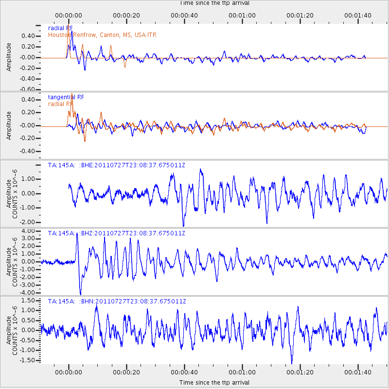
Signal To Noise
| Channel | StoN | STA | LTA |
| TA:145A: :BHZ:20110727T23:08:37.675011Z | 10.246204 | 1.8042715E-6 | 1.760917E-7 |
| TA:145A: :BHN:20110727T23:08:37.675011Z | 0.69929093 | 1.9244905E-7 | 2.75206E-7 |
| TA:145A: :BHE:20110727T23:08:37.675011Z | 1.3675773 | 4.3483556E-7 | 3.179605E-7 |
| Arrivals |
| Ps | 1.2 SECOND |
| PpPs | 4.6 SECOND |
| PsPs/PpSs | 5.8 SECOND |


