You are here: Home > Network List > TA - USArray Transportable Network (new EarthScope stations) Stations List
> Station 147A Livingston, AL, USA > Earthquake Result Viewer
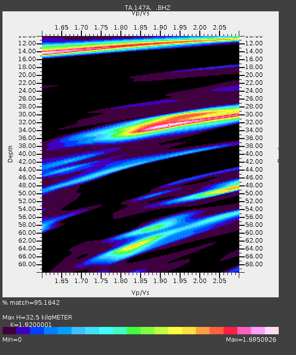
147A Livingston, AL, USA - Earthquake Result Viewer
| Earthquake location: |
Northern Mid-Atlantic Ridge |
| Earthquake latitude/longitude: |
10.8/-43.4 |
| Earthquake time(UTC): |
2011/07/27 (208) 23:00:30 GMT |
| Earthquake Depth: |
10 km |
| Earthquake Magnitude: |
5.6 MB, 5.6 MS, 6.0 MW, 5.9 MW |
| Earthquake Catalog/Contributor: |
WHDF/NEIC |
|
| Network: |
TA USArray Transportable Network (new EarthScope stations) |
| Station: |
147A Livingston, AL, USA |
| Lat/Lon: |
32.67 N/88.27 W |
| Elevation: |
57 m |
|
| Distance: |
46.6 deg |
| Az: |
304.995 deg |
| Baz: |
107.384 deg |
| Ray Param: |
0.0705508 |
| Estimated Moho Depth: |
32.5 km |
| Estimated Crust Vp/Vs: |
1.92 |
| Assumed Crust Vp: |
6.201 km/s |
| Estimated Crust Vs: |
3.23 km/s |
| Estimated Crust Poisson's Ratio: |
0.31 |
|
| Radial Match: |
95.1642 % |
| Radial Bump: |
366 |
| Transverse Match: |
83.83171 % |
| Transverse Bump: |
343 |
| SOD ConfigId: |
405110 |
| Insert Time: |
2011-12-29 09:24:06.089 +0000 |
| GWidth: |
2.5 |
| Max Bumps: |
400 |
| Tol: |
0.001 |
|

Signal To Noise
| Channel | StoN | STA | LTA |
| TA:147A: :BHZ:20110727T23:08:27.425011Z | 10.630452 | 1.0244445E-6 | 9.636885E-8 |
| TA:147A: :BHN:20110727T23:08:27.425011Z | 2.1016417 | 3.2296475E-7 | 1.5367262E-7 |
| TA:147A: :BHE:20110727T23:08:27.425011Z | 5.085748 | 6.085677E-7 | 1.196614E-7 |
| Arrivals |
| Ps | 5.1 SECOND |
| PpPs | 15 SECOND |
| PsPs/PpSs | 20 SECOND |


