You are here: Home > Network List > TA - USArray Transportable Network (new EarthScope stations) Stations List
> Station Y47A UCPARC, Winfield, AL, USA > Earthquake Result Viewer
Y47A UCPARC, Winfield, AL, USA - Earthquake Result Viewer
| Earthquake location: |
Northern Mid-Atlantic Ridge |
| Earthquake latitude/longitude: |
10.8/-43.4 |
| Earthquake time(UTC): |
2011/07/27 (208) 23:00:30 GMT |
| Earthquake Depth: |
10 km |
| Earthquake Magnitude: |
5.6 MB, 5.6 MS, 6.0 MW, 5.9 MW |
| Earthquake Catalog/Contributor: |
WHDF/NEIC |
|
| Network: |
TA USArray Transportable Network (new EarthScope stations) |
| Station: |
Y47A UCPARC, Winfield, AL, USA |
| Lat/Lon: |
33.90 N/87.85 W |
| Elevation: |
160 m |
|
| Distance: |
46.6 deg |
| Az: |
306.749 deg |
| Baz: |
108.819 deg |
| Ray Param: |
0.07052276 |
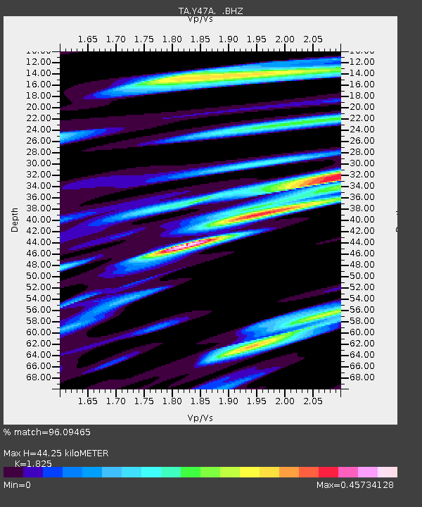
| Estimated Moho Depth: |
44.25 km |
| Estimated Crust Vp/Vs: |
1.83 |
| Assumed Crust Vp: |
6.565 km/s |
| Estimated Crust Vs: |
3.597 km/s |
| Estimated Crust Poisson's Ratio: |
0.29 |
|
| Radial Match: |
96.09465 % |
| Radial Bump: |
307 |
| Transverse Match: |
80.76783 % |
| Transverse Bump: |
400 |
| SOD ConfigId: |
405110 |
| Insert Time: |
2011-12-29 09:24:20.964 +0000 |
| GWidth: |
2.5 |
| Max Bumps: |
400 |
| Tol: |
0.001 |
|
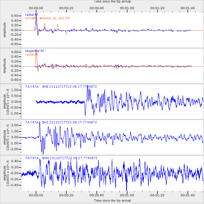
Signal To Noise
| Channel | StoN | STA | LTA |
| TA:Y47A: :BHZ:20110727T23:08:27.774987Z | 25.299969 | 1.1464625E-6 | 4.5314778E-8 |
| TA:Y47A: :BHN:20110727T23:08:27.774987Z | 3.380745 | 2.0166992E-7 | 5.965251E-8 |
| TA:Y47A: :BHE:20110727T23:08:27.774987Z | 10.852258 | 5.4030824E-7 | 4.9787634E-8 |
| Arrivals |
| Ps | 5.9 SECOND |
| PpPs | 18 SECOND |
| PsPs/PpSs | 24 SECOND |


