You are here: Home > Network List > TA - USArray Transportable Network (new EarthScope stations) Stations List
> Station Y45A Yeager Farm, Coffeeville, MS, USA > Earthquake Result Viewer
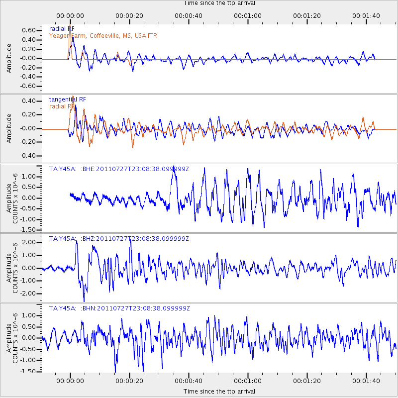
Y45A Yeager Farm, Coffeeville, MS, USA - Earthquake Result Viewer
*The percent match for this event was below the threshold and hence no stack was calculated.
| Earthquake location: |
Northern Mid-Atlantic Ridge |
| Earthquake latitude/longitude: |
10.8/-43.4 |
| Earthquake time(UTC): |
2011/07/27 (208) 23:00:30 GMT |
| Earthquake Depth: |
10 km |
| Earthquake Magnitude: |
5.6 MB, 5.6 MS, 6.0 MW, 5.9 MW |
| Earthquake Catalog/Contributor: |
WHDF/NEIC |
|
| Network: |
TA USArray Transportable Network (new EarthScope stations) |
| Station: |
Y45A Yeager Farm, Coffeeville, MS, USA |
| Lat/Lon: |
33.87 N/89.54 W |
| Elevation: |
106 m |
|
| Distance: |
48.0 deg |
| Az: |
306.105 deg |
| Baz: |
107.442 deg |
| Ray Param: |
$rayparam |
*The percent match for this event was below the threshold and hence was not used in the summary stack. |
|
| Radial Match: |
77.00114 % |
| Radial Bump: |
400 |
| Transverse Match: |
68.46038 % |
| Transverse Bump: |
400 |
| SOD ConfigId: |
405110 |
| Insert Time: |
2011-12-29 09:24:35.900 +0000 |
| GWidth: |
2.5 |
| Max Bumps: |
400 |
| Tol: |
0.001 |
|
Signal To Noise
| Channel | StoN | STA | LTA |
| TA:Y45A: :BHZ:20110727T23:08:38.099999Z | 11.031811 | 1.0922189E-6 | 9.9006314E-8 |
| TA:Y45A: :BHN:20110727T23:08:38.099999Z | 1.4456004 | 3.167225E-7 | 2.1909408E-7 |
| TA:Y45A: :BHE:20110727T23:08:38.099999Z | 2.8923073 | 4.6973844E-7 | 1.6240959E-7 |
| Arrivals |
| Ps | |
| PpPs | |
| PsPs/PpSs | |


