You are here: Home > Network List > TA - USArray Transportable Network (new EarthScope stations) Stations List
> Station Z46A Louisville, MS, USA > Earthquake Result Viewer
Z46A Louisville, MS, USA - Earthquake Result Viewer

| Earthquake location: |
Northern Mid-Atlantic Ridge |
| Earthquake latitude/longitude: |
10.8/-43.4 |
| Earthquake time(UTC): |
2011/07/27 (208) 23:00:30 GMT |
| Earthquake Depth: |
10 km |
| Earthquake Magnitude: |
5.6 MB, 5.6 MS, 6.0 MW, 5.9 MW |
| Earthquake Catalog/Contributor: |
WHDF/NEIC |
|
| Network: |
TA USArray Transportable Network (new EarthScope stations) |
| Station: |
Z46A Louisville, MS, USA |
| Lat/Lon: |
33.19 N/88.94 W |
| Elevation: |
125 m |
|
| Distance: |
47.3 deg |
| Az: |
305.442 deg |
| Baz: |
107.326 deg |
| Ray Param: |
0.070094004 |
| Estimated Moho Depth: |
11.0 km |
| Estimated Crust Vp/Vs: |
1.61 |
| Assumed Crust Vp: |
6.201 km/s |
| Estimated Crust Vs: |
3.852 km/s |
| Estimated Crust Poisson's Ratio: |
0.19 |
|
| Radial Match: |
88.595825 % |
| Radial Bump: |
400 |
| Transverse Match: |
80.444016 % |
| Transverse Bump: |
400 |
| SOD ConfigId: |
405110 |
| Insert Time: |
2011-12-29 09:25:08.307 +0000 |
| GWidth: |
2.5 |
| Max Bumps: |
400 |
| Tol: |
0.001 |
|
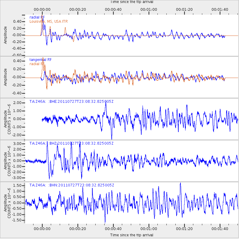
Signal To Noise
| Channel | StoN | STA | LTA |
| TA:Z46A: :BHZ:20110727T23:08:32.825005Z | 6.31161 | 1.3514533E-6 | 2.141218E-7 |
| TA:Z46A: :BHN:20110727T23:08:32.825005Z | 1.2218164 | 3.0170483E-7 | 2.469314E-7 |
| TA:Z46A: :BHE:20110727T23:08:32.825005Z | 2.5881007 | 6.075437E-7 | 2.34745E-7 |
| Arrivals |
| Ps | 1.2 SECOND |
| PpPs | 4.3 SECOND |
| PsPs/PpSs | 5.5 SECOND |


