You are here: Home > Network List > TA - USArray Transportable Network (new EarthScope stations) Stations List
> Station J41A Loganville, WI, USA > Earthquake Result Viewer
J41A Loganville, WI, USA - Earthquake Result Viewer
| Earthquake location: |
Northern Mid-Atlantic Ridge |
| Earthquake latitude/longitude: |
10.8/-43.4 |
| Earthquake time(UTC): |
2011/07/27 (208) 23:00:30 GMT |
| Earthquake Depth: |
10 km |
| Earthquake Magnitude: |
5.6 MB, 5.6 MS, 6.0 MW, 5.9 MW |
| Earthquake Catalog/Contributor: |
WHDF/NEIC |
|
| Network: |
TA USArray Transportable Network (new EarthScope stations) |
| Station: |
J41A Loganville, WI, USA |
| Lat/Lon: |
43.37 N/90.01 W |
| Elevation: |
360 m |
|
| Distance: |
51.7 deg |
| Az: |
317.526 deg |
| Baz: |
114.533 deg |
| Ray Param: |
0.06723003 |
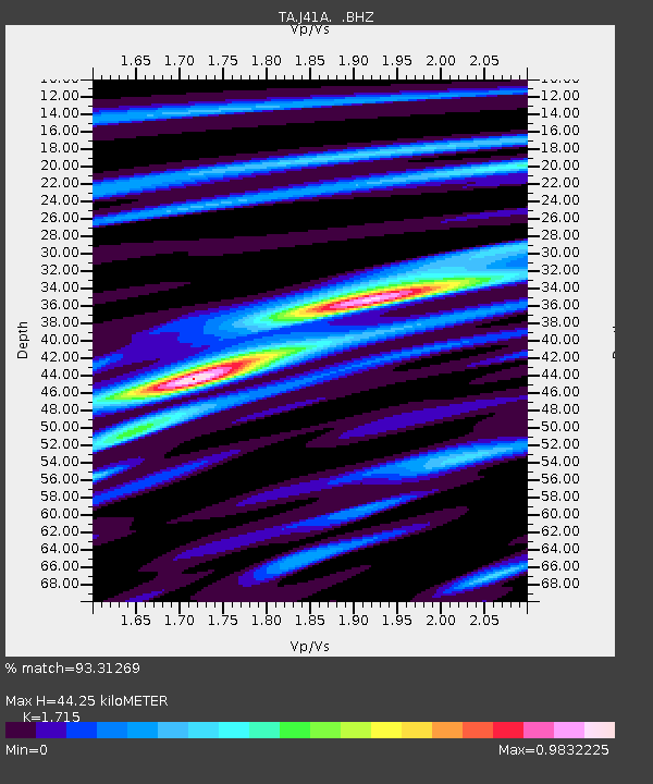
| Estimated Moho Depth: |
44.25 km |
| Estimated Crust Vp/Vs: |
1.72 |
| Assumed Crust Vp: |
6.53 km/s |
| Estimated Crust Vs: |
3.808 km/s |
| Estimated Crust Poisson's Ratio: |
0.24 |
|
| Radial Match: |
93.31269 % |
| Radial Bump: |
400 |
| Transverse Match: |
65.13111 % |
| Transverse Bump: |
400 |
| SOD ConfigId: |
405110 |
| Insert Time: |
2011-12-29 09:28:17.642 +0000 |
| GWidth: |
2.5 |
| Max Bumps: |
400 |
| Tol: |
0.001 |
|

Signal To Noise
| Channel | StoN | STA | LTA |
| TA:J41A: :BHZ:20110727T23:09:06.624993Z | 8.472883 | 6.941937E-7 | 8.1931226E-8 |
| TA:J41A: :BHN:20110727T23:09:06.624993Z | 3.811707 | 2.2662532E-7 | 5.9455076E-8 |
| TA:J41A: :BHE:20110727T23:09:06.624993Z | 5.7728586 | 3.7736442E-7 | 6.5368724E-8 |
| Arrivals |
| Ps | 5.1 SECOND |
| PpPs | 17 SECOND |
| PsPs/PpSs | 22 SECOND |


