You are here: Home > Network List > TA - USArray Transportable Network (new EarthScope stations) Stations List
> Station J40A Soldiers Grove, WI, USA > Earthquake Result Viewer
J40A Soldiers Grove, WI, USA - Earthquake Result Viewer
| Earthquake location: |
Northern Mid-Atlantic Ridge |
| Earthquake latitude/longitude: |
10.8/-43.4 |
| Earthquake time(UTC): |
2011/07/27 (208) 23:00:30 GMT |
| Earthquake Depth: |
10 km |
| Earthquake Magnitude: |
5.6 MB, 5.6 MS, 6.0 MW, 5.9 MW |
| Earthquake Catalog/Contributor: |
WHDF/NEIC |
|
| Network: |
TA USArray Transportable Network (new EarthScope stations) |
| Station: |
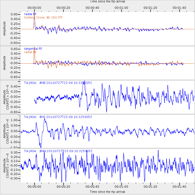
J40A Soldiers Grove, WI, USA |
| Lat/Lon: |
43.40 N/90.74 W |
| Elevation: |
353 m |
|
| Distance: |
52.2 deg |
| Az: |
317.286 deg |
| Baz: |
113.887 deg |
| Ray Param: |
0.06690234 |
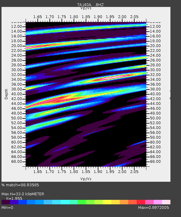
| Estimated Moho Depth: |
33.0 km |
| Estimated Crust Vp/Vs: |
1.96 |
| Assumed Crust Vp: |
6.53 km/s |
| Estimated Crust Vs: |
3.34 km/s |
| Estimated Crust Poisson's Ratio: |
0.32 |
|
| Radial Match: |
88.93585 % |
| Radial Bump: |
400 |
| Transverse Match: |
63.041115 % |
| Transverse Bump: |
400 |
| SOD ConfigId: |
405110 |
| Insert Time: |
2011-12-29 09:28:33.221 +0000 |
| GWidth: |
2.5 |
| Max Bumps: |
400 |
| Tol: |
0.001 |
|
Signal To Noise
| Channel | StoN | STA | LTA |
| TA:J40A: :BHZ:20110727T23:09:10.325005Z | 13.14638 | 7.092682E-7 | 5.3951595E-8 |
| TA:J40A: :BHN:20110727T23:09:10.325005Z | 2.557518 | 1.4777687E-7 | 5.778136E-8 |
| TA:J40A: :BHE:20110727T23:09:10.325005Z | 5.2947865 | 3.35092E-7 | 6.328717E-8 |
| Arrivals |
| Ps | 5.1 SECOND |
| PpPs | 14 SECOND |
| PsPs/PpSs | 19 SECOND |


