You are here: Home > Network List > TA - USArray Transportable Network (new EarthScope stations) Stations List
> Station P42A Winchester, IL, USA > Earthquake Result Viewer
P42A Winchester, IL, USA - Earthquake Result Viewer
| Earthquake location: |
Northern Mid-Atlantic Ridge |
| Earthquake latitude/longitude: |
10.8/-43.4 |
| Earthquake time(UTC): |
2011/07/27 (208) 23:00:30 GMT |
| Earthquake Depth: |
10 km |
| Earthquake Magnitude: |
5.6 MB, 5.6 MS, 6.0 MW, 5.9 MW |
| Earthquake Catalog/Contributor: |
WHDF/NEIC |
|
| Network: |
TA USArray Transportable Network (new EarthScope stations) |
| Station: |
P42A Winchester, IL, USA |
| Lat/Lon: |
39.59 N/90.34 W |
| Elevation: |
197 m |
|
| Distance: |
50.5 deg |
| Az: |
312.932 deg |
| Baz: |
111.428 deg |
| Ray Param: |
0.06803482 |
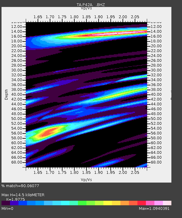
| Estimated Moho Depth: |
14.5 km |
| Estimated Crust Vp/Vs: |
1.98 |
| Assumed Crust Vp: |
6.498 km/s |
| Estimated Crust Vs: |
3.286 km/s |
| Estimated Crust Poisson's Ratio: |
0.33 |
|
| Radial Match: |
90.06077 % |
| Radial Bump: |
400 |
| Transverse Match: |
67.18916 % |
| Transverse Bump: |
400 |
| SOD ConfigId: |
405110 |
| Insert Time: |
2011-12-29 09:28:48.824 +0000 |
| GWidth: |
2.5 |
| Max Bumps: |
400 |
| Tol: |
0.001 |
|
Signal To Noise
| Channel | StoN | STA | LTA |
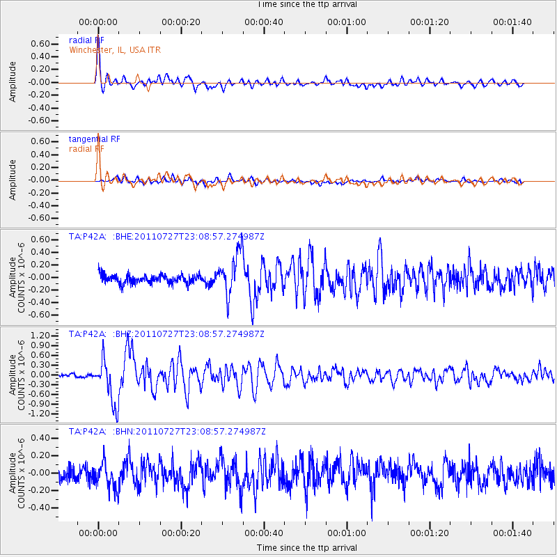
| TA:P42A: :BHZ:20110727T23:08:57.274987Z | 10.051972 | 6.9840695E-7 | 6.947959E-8 |
| TA:P42A: :BHN:20110727T23:08:57.274987Z | 2.2584128 | 1.6053879E-7 | 7.1084784E-8 |
| TA:P42A: :BHE:20110727T23:08:57.274987Z | 5.1816134 | 3.567233E-7 | 6.884406E-8 |
| Arrivals |
| Ps | 2.3 SECOND |
| PpPs | 6.3 SECOND |
| PsPs/PpSs | 8.6 SECOND |


